
Ladawan:Palestine election map.PNG

Pakadakula kan pasirip na ini: 437 × 600 na pixel. Ibang mga resolusyon: 175 × 240 na pixel | 350 × 480 na pixel | 560 × 768 na pixel | 1,115 × 1,530 na pixel.
Orihinal na file (1,115 × 1,530 na pixel, pakadakula: 106 KB, tipo nin MIME: image/png)

|
This election map image could be re-created using vector graphics as an SVG file. This has several advantages; see Commons:Media for cleanup for more information. If an SVG form of this image is available, please upload it and afterwards replace this template with
{{vector version available|new image name}}.
It is recommended to name the SVG file “Palestine election map.svg”—then the template Vector version available (or Vva) does not need the new image name parameter. |
Sumaryo
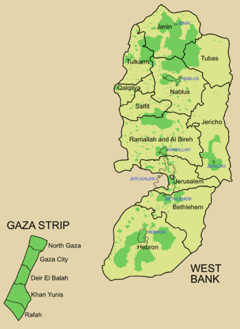
Palestine divided into electoral districts (as of 2006), marked with thick black borders. (thinner borders show boundaries of cities, with city names marked in blue). Green shows areas of formal Palestinian authority. Map made using information from other maps such as this. There is a map of the West Bank and Gaza governates from 1995 here
Paglisensya

|
Tinutugutan an pagkopya, pagpanao, asin/o pagbago sa dokumentong ini sa irarom kan mga termino kan GNU Free Documentation License, Bersyon 1.2 o dawa anong mas bagong bersyon na naipublikar kan Free Software Foundation; na mayong paburubagong seksyon, mayong teksto sa front-cover, asin walang teksto sa back-cover. Igwang nakalaag na kopya kan lisensya sa seksyon na may titulong GNU Free Documentation License. |
| Nakalisensya an file na ini sa irarom kan lisensyang Creative Commons Attribution-Share Alike 3.0 Unported. | ||
| ||
| This licensing tag was added to this file as part of the GFDL licensing update. |
Kasaysayan kan file
Pinduton an sarong petsa/oras para mahiling ng file sa puntong idto.
| Petsa/Oras | Thumbnail | Sukol | Paragamit | Komento | |
|---|---|---|---|---|---|
| presente | 09:57, 5 Hulyo 2006 | | 1,115 × 1,530 (106 KB) | Roke~commonswiki | request to make all of gaza strip dark green |
| 05:38, 28 Enero 2006 |  | 1,115 × 1,530 (104 KB) | Roke~commonswiki | Palestine divided into electoral districts, marked with black borders. Green shows areas of formal Palestinian authority. I made the map, using information from other maps such as [http://www.nytimes.com/imagepages/2006/01/25/international/20060125_palest |
Paggamit sa file
Ginagamit kan minasunod na pahina an file na ini:
Pankinaban na paggamit sa file
Ginagamit kan mga minasunod na wiki an file na ini:
- Paggamit sa arz.wikipedia.org
- Paggamit sa be.wikipedia.org
- Paggamit sa bn.wikipedia.org
- Paggamit sa br.wikipedia.org
- Paggamit sa ca.wikipedia.org
- Paggamit sa cs.wikipedia.org
- Paggamit sa en.wikipedia.org
- Palestinian territories
- State of Palestine
- List of cities administered by the Palestinian Authority
- Governorates of Palestine
- Template talk:Governorates of the State of Palestine
- Next Palestinian legislative election
- Condoleezza Rice's tenure as Secretary of State
- Talk:Next Palestinian legislative election
- 2006 Palestinian legislative election
- User:Falcaorib
- Paggamit sa en.wikinews.org
- Paggamit sa eo.wikipedia.org
- Paggamit sa es.wikipedia.org
- Paggamit sa es.wikinews.org
- Paggamit sa fa.wikipedia.org
- Paggamit sa fr.wikipedia.org
- Paggamit sa gv.wikipedia.org
- Paggamit sa he.wikipedia.org
- Paggamit sa hy.wikipedia.org
- Paggamit sa id.wikipedia.org
- Paggamit sa it.wikipedia.org
- Paggamit sa ja.wikipedia.org
- Paggamit sa ja.wikinews.org
- Paggamit sa ko.wikipedia.org
- Paggamit sa ms.wikipedia.org
- Paggamit sa nap.wikipedia.org
Hilingon an kadagdagan na pankinaban na paggamit sa file na ini.