
Ladawan:CSA states evolution.gif
Pakadakula kan pasirip na ini: 800 × 542 na pixel. Ibang mga resolusyon: 320 × 217 na pixel | 640 × 433 na pixel | 1,000 × 677 na pixel.
Orihinal na file (1,000 × 677 na pixel, pakadakula: 245 KB, tipo nin MIME: image/gif, pinag-otro, 38 mga prema, 1 min 53 s)
Sumaryo
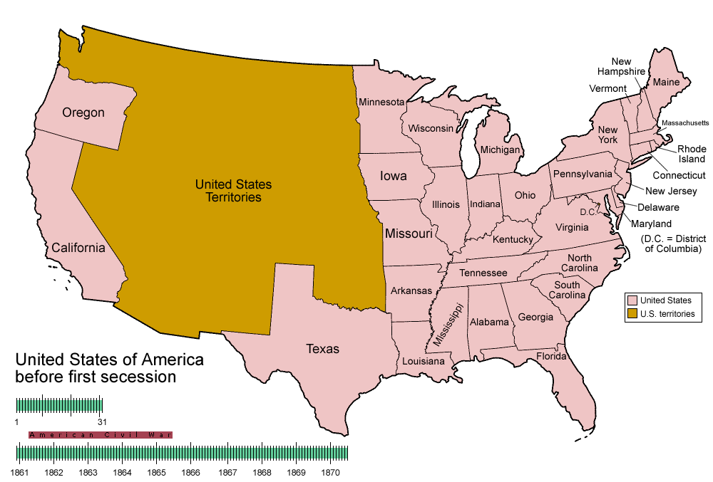
| Pagladawan | Animated map/timeline of the territorial evolution of the Confederate States of America, from first secession to end of Reconstruction. |
| Petsa | |
| Pinagkunan | Sadiring gibo |
| Kagsurat | User:Golbez |
|
Paglisensya
I, the copyright holder of this work, hereby publish it under the following licenses:

|
Tinutugutan an pagkopya, pagpanao, asin/o pagbago sa dokumentong ini sa irarom kan mga termino kan GNU Free Documentation License, Bersyon 1.2 o dawa anong mas bagong bersyon na naipublikar kan Free Software Foundation; na mayong paburubagong seksyon, mayong teksto sa front-cover, asin walang teksto sa back-cover. Igwang nakalaag na kopya kan lisensya sa seksyon na may titulong GNU Free Documentation License. |
| Nakalisensya an file na ini sa irarom kan lisensyang Creative Commons Attribution-Share Alike 3.0 Unported. | ||
| ||
| This licensing tag was added to this file as part of the GFDL licensing update. |
This file is licensed under the Creative Commons Attribution-Share Alike 2.5 Generic, 2.0 Generic and 1.0 Generic license.
- Talingkas mo ining:
- maihiras – makokopya, maipapanao, asin maipapahiling an gibo
- i-remix – ma-adapt an gibo
- Sa irarom kan mga kondisyon na ini:
- atribusyon – Dapat mong i-credit, itao an link kan lisensya, at itukdo kun may binago ini. Pwede mo ining gibuhon sa dawa anong rasonableng paagi, pero bako sa paaging ineendorso ka o an paggamit mo kan naglisensya.
- share alike – Kun ire-remix mo, babaguhon, o madagdag sa materyal, kaipuhan mong ipanao an mga ambag mo sa irarom kan parehas o katulad na lisensya.
Pwede kang makapili nin lisensya mo.
Kasaysayan kan file
Pinduton an sarong petsa/oras para mahiling ng file sa puntong idto.
| Petsa/Oras | Thumbnail | Sukol | Paragamit | Komento | |
|---|---|---|---|---|---|
| presente | 05:30, 5 Hunyo 2014 | | 1,000 × 677 (245 KB) | RedXIV | Removed incorrect information. Kentucky and Missouri never seceded. The state governments of Kentucky and Missouri never voted to secede. Claiming that their secession actually happened gives an inaccurate impression of the actual sequence of events. |
| 10:56, 21 Disyembre 2013 |  | 1,000 × 677 (256 KB) | ChrisnHouston | I'm the one who broke the thumbnail. I'll try to fix it now... | |
| 13:38, 20 Disyembre 2013 |  | 1,000 × 677 (1.75 MB) | Afernand74 | No image displayed. Reupload to try to solve the problem | |
| 11:33, 7 Nobyembre 2013 |  | 1,000 × 677 (1.75 MB) | ChrisnHouston | Adding a bar to the timeline to indicate when the actual fighting of the Civil War happened, which is one of the most important aspects of this map. | |
| 15:18, 11 Abril 2012 |  | 1,000 × 677 (254 KB) | Golbez | rv - er, MO and KY were indeed admitted to the CSA, though it lacked any control over them. why not go to the talk page for the CSA on enwp and chat about my next version? | |
| 18:53, 10 Abril 2012 |  | 1,000 × 677 (225 KB) | Travürsa | Fixed errors. | |
| 01:57, 18 Nobyembre 2007 |  | 1,000 × 677 (254 KB) | Golbez | Removing frame of WV counties; that was incorrect, they were always part of WV | |
| 09:54, 4 Marso 2007 |  | 1,000 × 677 (259 KB) | Golbez | == Summary == {{Information |Description=Animated map/timeline of the territorial evolution of the Confederate States of America, from first secession to end of Reconstruction. |Source=Self-made. |Date=March 2007 |Author=User:Golbez |Permission= see b |
Paggamit sa file
Ginagamit kan minasunod na pahina an file na ini:
Pankinaban na paggamit sa file
Ginagamit kan mga minasunod na wiki an file na ini:
- Paggamit sa af.wikipedia.org
- Paggamit sa cs.wikipedia.org
- Paggamit sa da.wikipedia.org
- Paggamit sa de.wikipedia.org
- Paggamit sa en.wikipedia.org
- Confederate States of America
- Portal:United States/Selected picture
- User talk:-asx-
- User talk:Golbez/Archive 2
- Portal:Maps/Selected picture
- Wikipedia:Featured picture candidates/March-2007
- Wikipedia:Picture peer review/CSA evolution
- Wikipedia:Featured picture candidates/CSA states evolution.gif
- Wikipedia:Wikipedia Signpost/2007-03-20/Features and admins
- Wikipedia:Wikipedia Signpost/2007-03-20/SPV
- Portal:Maps/Selected picture/11
- Portal:United States/Selected picture/15
- Wikipedia:Featured picture candidates/November-2009
- Wikipedia:Featured picture candidates/Non-Native American Nations Control over N America 1750-2008.gif
- Wikipedia:Featured picture candidates/delist/2010
- Wikipedia:Featured picture candidates/delist/File:CSA states evolution.gif
- User:TheVirginiaHistorian/sandbox
- Wikipedia:Village pump (technical)/Archive 110
- Wikipedia:Wikipedia Signpost/Single/2007-03-20
- Paggamit sa eo.wikipedia.org
- Paggamit sa eu.wikipedia.org
- Paggamit sa fr.wikipedia.org
- Paggamit sa fr.wiktionary.org
- Paggamit sa fy.wikipedia.org
- Paggamit sa hr.wikipedia.org
- Paggamit sa hu.wikipedia.org
- Paggamit sa id.wikipedia.org
- Paggamit sa ja.wikipedia.org
- Paggamit sa la.wikipedia.org
- Paggamit sa ms.wikipedia.org
- Paggamit sa pt.wikipedia.org
- Paggamit sa ro.wikipedia.org
- Paggamit sa sr.wikipedia.org
- Paggamit sa th.wikipedia.org
- Paggamit sa tr.wikipedia.org
- Paggamit sa uk.wikipedia.org