
Ladawan:Fakaofo Satellite NASA.jpg

Pakadakula kan pasirip na ini: 800 × 529 na pixel. Ibang mga resolusyon: 320 × 212 na pixel | 640 × 423 na pixel | 1,024 × 677 na pixel | 1,280 × 846 na pixel | 3,032 × 2,004 na pixel.
Orihinal na file (3,032 × 2,004 na pixel, pakadakula: 540 KB, tipo nin MIME: image/jpeg)
Sumaryo
| Pagladawan | |
| Petsa | |
| Pinagkunan |
|
| Kagsurat | NASA Johnson Space Center |
| Object location | | View this and other nearby images on: OpenStreetMap |
|---|
This image or video was catalogued by one of the centers of the United States National Aeronautics and Space Administration (NASA) under Photo ID: ISS006-E-39657. This tag does not indicate the copyright status of the attached work. A normal copyright tag is still required. See Commons:Licensing. Other languages:
|
Paglisensya
| This file is in the public domain in the United States because it was solely created by NASA. NASA copyright policy states that "NASA material is not protected by copyright unless noted". (See Template:PD-USGov, NASA copyright policy page or JPL Image Use Policy.) | ||
 |
Warnings:
|

|
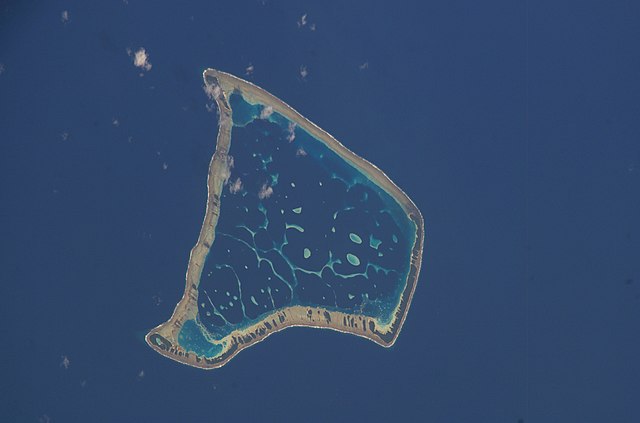
This image has been assessed under the valued image criteria and is considered the most valued image on Commons within the scope: Fakaofo atoll, Tokelau - satellite view. You can see its nomination here. |
Kasaysayan kan file
Pinduton an sarong petsa/oras para mahiling ng file sa puntong idto.
| Petsa/Oras | Thumbnail | Sukol | Paragamit | Komento | |
|---|---|---|---|---|---|
| presente | 00:07, 18 Disyembre 2014 | | 3,032 × 2,004 (540 KB) | Fundatus | Removed caption |
| 20:53, 5 Abril 2008 |  | 3,032 × 2,064 (682 KB) | Gugganij | == Summary == {{Information |Description=*{{en|Satellite picture of the Fakaofo atoll in Tokelau.}} *{{de|Satellitenbild des Fakaofo Atolls in Tokelau.}} |Source=*[http://eol.jsc.nasa.gov/scripts/sseop/photo.pl?mission=ISS006&roll=E&frame=39657 As |
Paggamit sa file
Ginagamit kan minasunod na pahina an file na ini:
Pankinaban na paggamit sa file
Ginagamit kan mga minasunod na wiki an file na ini:
- Paggamit sa ast.wikipedia.org
- Paggamit sa azb.wikipedia.org
- Paggamit sa ca.wikipedia.org
- Paggamit sa ceb.wikipedia.org
- Paggamit sa de.wikipedia.org
- Paggamit sa en.wikipedia.org
- Paggamit sa es.wikipedia.org
- Paggamit sa fr.wikipedia.org
- Paggamit sa id.wikipedia.org
- Paggamit sa is.wikipedia.org
- Paggamit sa ja.wikipedia.org
- Paggamit sa nl.wikipedia.org
- Paggamit sa no.wikipedia.org
- Paggamit sa pl.wikipedia.org
- Paggamit sa pt.wikipedia.org
- Paggamit sa ro.wikipedia.org
- Paggamit sa ru.wikipedia.org
- Paggamit sa sv.wikipedia.org
- Paggamit sa tr.wikipedia.org
- Paggamit sa tt.wikipedia.org
- Paggamit sa uk.wikipedia.org
- Paggamit sa vi.wikipedia.org
- Paggamit sa www.wikidata.org
- Paggamit sa zh.wikipedia.org