
Ladawan:Mount mantalingahan palawan.jpg
Mayo na nin mas malinaw.
Mount_mantalingahan_palawan.jpg (640 × 427 na pixel, pakadakula: 302 KB, tipo nin MIME: image/jpeg)
Sumaryo
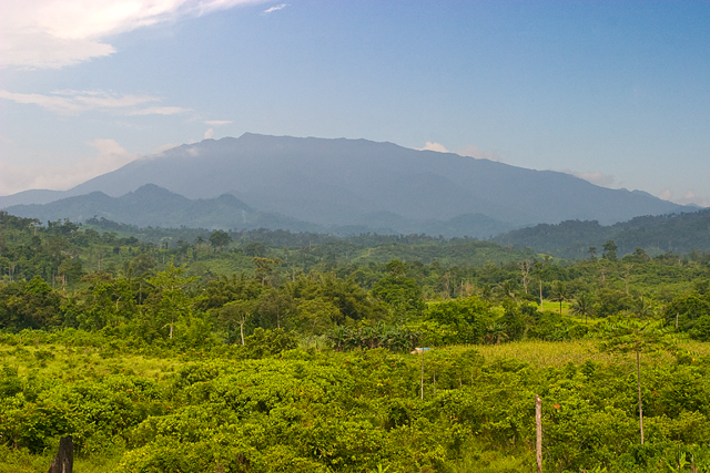
| Pagladawan | Mount Mantalingahan, an ultramafic peak of 2085 m, photographed from the barangay of Ransang, Rizal municipality, Philippines. The summit ridge is two to three days distant on foot, and one and a half days on the downward return journey (Alastair Robinson, July 2007). | ||
| Petsa | 24 Nobyembre 2007 (original upload date) | ||
| Pinagkunan | Transfered from en.wikipedia | ||
| Kagsurat | Original uploader was Alastair Robinson at en.wikipedia | ||
| Pagtugot (Giraray na paggamit sa file) |
|
Paglisensya
Alastair Robinson at en.wikipedia, the copyright holder of this work, hereby publishes it under the following license:
This file is licensed under the Creative Commons Attribution 3.0 Unported license.
Atribusyon: Alastair Robinson at en.wikipedia
- Talingkas mo ining:
- maihiras – makokopya, maipapanao, asin maipapahiling an gibo
- i-remix – ma-adapt an gibo
- Sa irarom kan mga kondisyon na ini:
- atribusyon – Dapat mong i-credit, itao an link kan lisensya, at itukdo kun may binago ini. Pwede mo ining gibuhon sa dawa anong rasonableng paagi, pero bako sa paaging ineendorso ka o an paggamit mo kan naglisensya.
Original upload log
The original description page is/was here. All following user names refer to en.wikipedia.
- 2007-11-24 09:52 Alastair Robinson 640×427 (302 KB) Mount Mantalingahan, an [[ultramafic]] peak of 2085 [[metre|m]], photographed from the township of Ransang, [[Rizal, Palawan|Rizal Province]], [[Philippines]]. The summit ridge is two to three days distant on foot, and one and a half days on the downward return journey (Alastair Robinson, July 2007).
Kasaysayan kan file
Pinduton an sarong petsa/oras para mahiling ng file sa puntong idto.
| Petsa/Oras | Thumbnail | Sukol | Paragamit | Komento | |
|---|---|---|---|---|---|
| presente | 15:49, 6 Hunyo 2008 | | 640 × 427 (302 KB) | Ch.Andrew | {{Information |Description= Mount Mantalingahan, an ultramafic peak of 2085 m, photographed from the township of Ransang, Rizal Province, Philippines. The summit ridge is two to three days distant on foot, and one and |
Paggamit sa file
Ginagamit kan minasunod na pahina an file na ini:
Pankinaban na paggamit sa file
Ginagamit kan mga minasunod na wiki an file na ini:
- Paggamit sa af.wikipedia.org
- Paggamit sa ar.wikipedia.org
- Paggamit sa cbk-zam.wikipedia.org
- Paggamit sa ceb.wikipedia.org
- Paggamit sa de.wikipedia.org
- Paggamit sa en.wikipedia.org
- Paggamit sa es.wikipedia.org
- Paggamit sa fa.wikipedia.org
- Paggamit sa fr.wikipedia.org
- Paggamit sa hu.wikipedia.org
- Paggamit sa ilo.wikipedia.org
- Paggamit sa it.wikipedia.org
- Paggamit sa ka.wikipedia.org
- Paggamit sa lld.wikipedia.org
- Paggamit sa ms.wikipedia.org
- Paggamit sa nl.wikipedia.org
- Paggamit sa no.wikipedia.org
- Paggamit sa pag.wikipedia.org
- Paggamit sa pam.wikipedia.org
- Paggamit sa pt.wikipedia.org
- Paggamit sa ro.wikipedia.org
- Paggamit sa ru.wikipedia.org
- Paggamit sa sv.wikipedia.org
- Paggamit sa th.wikipedia.org
Hilingon an kadagdagan na pankinaban na paggamit sa file na ini.