
Ladawan:Ngongping360 sameboat.png
Mayo na nin mas malinaw.
Ngongping360_sameboat.png (412 × 490 na pixel, pakadakula: 28 KB, tipo nin MIME: image/png)
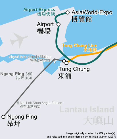
| Pagladawan | Route map focusing on Hong Kong cable car Ngong Ping 360 and the nearby railway system, in geographically accurate scale. | ||
| Petsa | |||
| Pinagkunan | Cropped and revised from image:Hong Kong Railway Route Map en.svg | ||
| Kagsurat | user:Sameboat | ||
| Pagtugot (Giraray na paggamit sa file) |
|
||
| Other versions | Image:Ngongping360 map.png & Image:NgongPing360 map.jpg |
Kasaysayan kan file
Pinduton an sarong petsa/oras para mahiling ng file sa puntong idto.
| Petsa/Oras | Thumbnail | Sukol | Paragamit | Komento | |
|---|---|---|---|---|---|
| presente | 10:37, 26 Disyembre 2007 | | 412 × 490 (28 KB) | Sameboat | {{Information |Description= |Source= |Date= |Author= |Permission= |other_versions= }} |
| 11:30, 14 Disyembre 2007 |  | 412 × 490 (28 KB) | Sameboat | {{Information |Description=Route map focusing on Hong Kong cable car Ngong Ping 360 and the nearby railway system, in geographically accurate scale. |Source=Cropped and revised from image:Hong Kong Railway Route Map en.svg |Date=December, 2007 |Aut |
Paggamit sa file
Ginagamit kan minasunod na pahina an file na ini:
Pankinaban na paggamit sa file
Ginagamit kan mga minasunod na wiki an file na ini:
- Paggamit sa de.wikipedia.org
- Paggamit sa en.wikipedia.org
- Paggamit sa he.wikipedia.org
- Paggamit sa sk.wikipedia.org
- Paggamit sa zh-yue.wikipedia.org
- Paggamit sa zh.wikipedia.org