
Ladawan:Palau - Location Map (2013) - PLW - UNOCHA.svg

Orihinal na file (SVG na file, nominal na 250 × 250 (na) pixel, pakadakula: 1.12 MB)
_-_PLW_-_UNOCHA.svg)
Sumaryo
| Pagladawan |
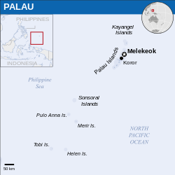
English: Locator map of Palau. |
| Petsa | |
| Pinagkunan |
English: Palau Locator Map (ReliefWeb) |
| Kagsurat | |
| SVG genesis |
Paglisensya
- Talingkas mo ining:
- maihiras – makokopya, maipapanao, asin maipapahiling an gibo
- i-remix – ma-adapt an gibo
- Sa irarom kan mga kondisyon na ini:
- atribusyon – Dapat mong i-credit, itao an link kan lisensya, at itukdo kun may binago ini. Pwede mo ining gibuhon sa dawa anong rasonableng paagi, pero bako sa paaging ineendorso ka o an paggamit mo kan naglisensya.
 This map is part of a collection of 216 free country maps, created by the UN Office for the Coordination of Humanitarian Affairs (OCHA), to be used in print, web or broadcast products.
The ReliefWeb Location Maps released here are maps that highlight a country, its capital, major populated places and the surrounding regions. Attribution Requirements
Using the map without modifications: ensure that the sources and the disclaimer are below the map. Credit as follows: "Credit: OCHA". For use with alteration: remove the OCHA logo and disclaimer following any modification to the map, but keep the data sources as mentioned below the map. Credit the modified map as follows: "Based on OCHA map". You are responsible for the content of your map. We are keen to receive your feedback and hear how you used OCHA's maps. We would be grateful if you would notify us by e-mail and share your work with us. UN Disclaimer
The designations employed and the presentation of material of this map do not imply the expression of any opinion whatsoever on the part of the Secretariat of the United Nations concerning the legal status of any country, territory, city or area or of its authorities or concerning the delimitation of its frontiers or boundaries. |

|
Textual information (e.g. timestamp) once visible in the image itself has been moved into the image metadata and/or image description page. This makes the image easier to reuse and more language-neutral, and makes the text easier to process and search for. Commons discourages placing visible textual information in images. All licenses accepted on Commons permit this type of modification as a derivative work.
If attribution information were removed and the image is not public domain, replace this tag with {{Attribution metadata from licensed image}}.
|
Kasaysayan kan file
Pinduton an sarong petsa/oras para mahiling ng file sa puntong idto.
| Petsa/Oras | Thumbnail | Sukol | Paragamit | Komento | |
|---|---|---|---|---|---|
| presente | 07:43, 10 Marso 2023 | | 250 × 250 (1.12 MB) | Illchy | File uploaded using svgtranslate tool (https://svgtranslate.toolforge.org/). Added translation for id. |
| 02:04, 29 Disyembre 2022 |  | 250 × 250 (1.12 MB) | Wikijahnn | File uploaded using svgtranslate tool (https://svgtranslate.toolforge.org/). Added translation for ca. | |
| 07:32, 3 Abril 2016 |  | 250 × 250 (1.12 MB) | Wereldburger758 | Resized page to drawing. Removal watermark. Validation of image. | |
| 00:53, 8 Mayo 2014 |  | 254 × 254 (1.08 MB) | UN OCHA maps bot | == {{int:filedesc}} == {{Information |description={{en|1=Locator map of Palau.}} |date=2013 |source={{en|1=[http://reliefweb.int/map/palau/palau-location-map-2013 Palau Locator Map (ReliefWeb)]}} |author={{en|1=[[w:en:United Nations Offi... |
Paggamit sa file
Ginagamit kan minasunod na pahina an file na ini:
Pankinaban na paggamit sa file
Ginagamit kan mga minasunod na wiki an file na ini:
- Paggamit sa ast.wikipedia.org
- Paggamit sa bg.wikipedia.org
- Paggamit sa bjn.wikipedia.org
- Paggamit sa bn.wikipedia.org
- Paggamit sa ca.wikipedia.org
- Paggamit sa cs.wikipedia.org
- Paggamit sa cy.wikipedia.org
- Paggamit sa dty.wikipedia.org
- Paggamit sa en.wikipedia.org
- Paggamit sa eu.wikipedia.org
- Paggamit sa fa.wikipedia.org
- Paggamit sa gu.wikipedia.org
- Paggamit sa hi.wikipedia.org
- Paggamit sa id.wikipedia.org
- Paggamit sa it.wikipedia.org
- Paggamit sa kcg.wikipedia.org
- Paggamit sa lld.wikipedia.org
- Paggamit sa mn.wikipedia.org
- Paggamit sa my.wikipedia.org
- Paggamit sa ps.wikipedia.org
- Paggamit sa ru.wikipedia.org
- Paggamit sa sat.wikipedia.org
- Paggamit sa sd.wikipedia.org
- Paggamit sa sr.wikipedia.org
- Paggamit sa sv.wikipedia.org
- Paggamit sa tt.wikipedia.org
- Paggamit sa www.wikidata.org
_-_PLW_-_UNOCHA.svg)