
Ladawan:Sunda Strait map-fr.svg

Size of this PNG preview of this SVG file: 800 × 535 na pixel. Ibang mga resolusyon: 320 × 214 na pixel | 640 × 428 na pixel | 1,024 × 685 na pixel | 1,280 × 857 na pixel | 2,560 × 1,713 na pixel | 3,579 × 2,395 na pixel.
Orihinal na file (SVG na file, nominal na 3,579 × 2,395 (na) pixel, pakadakula: 2.08 MB)
Sumaryo
| Pagladawan |
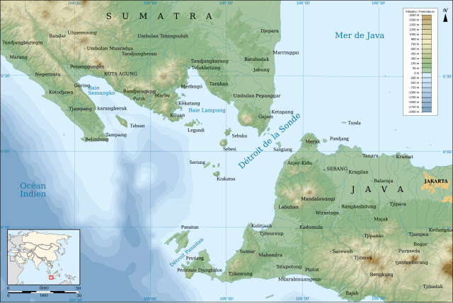
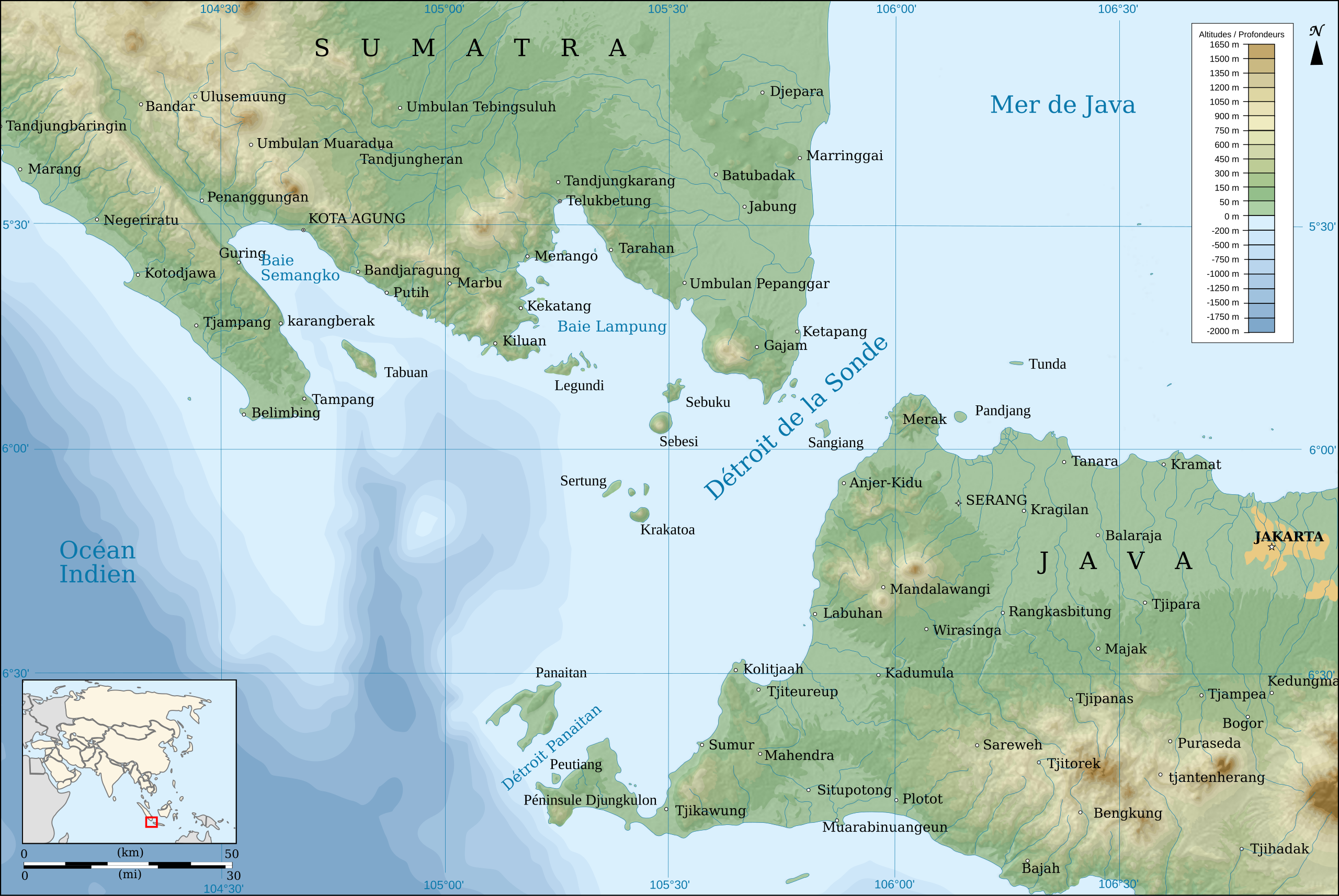
English: Map of the Sunda Strait, in french.
Français : Carte du Détroit de la Sonde, en français. |
||
| Petsa | |||
| Pinagkunan |
travail personnel. Source :
|
||
| Kagsurat | Pinpin | ||
| Other versions | |||
| SVG | W3C-validity not checked.
|
||
| Graphic Lab |

| Camera location | | View this and other nearby images on: OpenStreetMap |
|---|
Paglisensya
I, the copyright holder of this work, hereby publish it under the following licenses:
| Copyleft: This work of art is free; you can redistribute it and/or modify it according to terms of the Free Art License. You will find a specimen of this license on the Copyleft Attitude site as well as on other sites. |
This file is licensed under the Creative Commons Attribution-Share Alike 4.0 International, 3.0 Unported, 2.5 Generic, 2.0 Generic and 1.0 Generic license.
- Talingkas mo ining:
- maihiras – makokopya, maipapanao, asin maipapahiling an gibo
- i-remix – ma-adapt an gibo
- Sa irarom kan mga kondisyon na ini:
- atribusyon – Dapat mong i-credit, itao an link kan lisensya, at itukdo kun may binago ini. Pwede mo ining gibuhon sa dawa anong rasonableng paagi, pero bako sa paaging ineendorso ka o an paggamit mo kan naglisensya.
- share alike – Kun ire-remix mo, babaguhon, o madagdag sa materyal, kaipuhan mong ipanao an mga ambag mo sa irarom kan parehas o katulad na lisensya.
Pwede kang makapili nin lisensya mo.
Kasaysayan kan file
Pinduton an sarong petsa/oras para mahiling ng file sa puntong idto.
| Petsa/Oras | Thumbnail | Sukol | Paragamit | Komento | |
|---|---|---|---|---|---|
| presente | 12:40, 24 Disyembre 2018 | | 3,579 × 2,395 (2.08 MB) | Sémhur | Scale correction. |
| 11:39, 24 Abril 2008 |  | 3,579 × 2,395 (2.09 MB) | Sémhur | {{Information |Description= {{en|Map of the Sunda Strait, in french.}} {{fr|Carte du Détroit de la Sonde, en français.}} |Source=travail personnel. Source : * Fond de carte : [http://www2.jpl.nasa.gov/sr |
Paggamit sa file
Ginagamit kan minasunod na pahina an file na ini:
Pankinaban na paggamit sa file
Ginagamit kan mga minasunod na wiki an file na ini:
- Paggamit sa ban.wikipedia.org
- Paggamit sa bn.wikipedia.org
- Paggamit sa bs.wikinews.org
- Paggamit sa ca.wikipedia.org
- Paggamit sa cy.wikipedia.org
- Paggamit sa en.wikipedia.org
- Paggamit sa eo.wikipedia.org
- Paggamit sa es.wikipedia.org
- Paggamit sa eu.wikipedia.org
- Paggamit sa fr.wikipedia.org
- Paggamit sa gl.wikipedia.org
- Paggamit sa he.wikipedia.org
- Paggamit sa hi.wikipedia.org
- Paggamit sa hr.wikipedia.org
- Paggamit sa id.wikipedia.org
- Paggamit sa ja.wikipedia.org
- Paggamit sa ko.wikipedia.org
- Paggamit sa la.wikipedia.org
- Paggamit sa mk.wikipedia.org
- Paggamit sa ml.wikipedia.org
- Paggamit sa ms.wikipedia.org
- Paggamit sa nl.wikipedia.org
- Paggamit sa nn.wikipedia.org
- Paggamit sa oc.wikipedia.org
- Paggamit sa su.wikipedia.org
- Paggamit sa sw.wikipedia.org
- Paggamit sa vi.wikipedia.org
- Paggamit sa www.wikidata.org
- Paggamit sa zh-min-nan.wikipedia.org