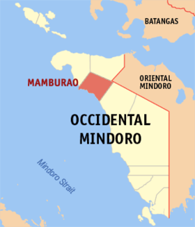
Mamburao
(Nakatukdo hali sa Mamburao, Occidental Mindoro)
Mamburao | |
|---|---|
 | |
 Kinamumugtakan kan Mamburao | |
 | |
| Tagboan: 13°13′24″N 120°35′46″E Tagboan: 13°13′24″N 120°35′46″E | |
| Nasyon | Filipinas |
| Pigtugdas | 1955 |
| Barangay | 15 |
| Pamamahala | |
| • Electorado | 30,393 votantes (9 Mayo 2022) |
| Hiwas | |
| • Kabuuhan | 283.51 km2 (109.46 sq mi) |
| Elebasyon | 8.8 m (28.9 ft) |
| Populasyon (Mayo 1, 2020)[1] | |
| • kabuuhan | 47,705 |
| • Densidad | 170/km2 (440/sq mi) |
| • Saro | 11,476 |
| Economia | |
| • Klase | ikaduwang klaseng banwaan |
| • Ingresos | ₱200,446,105.88 (2020) |
| • Activos | ₱453,953,242.30 (2020) |
| • Pasivos | ₱257,931,132.10 (2020) |
| • Gastos | ₱226,657,469.97 (2020) |
| Kodigo nin postal | 5106 |
| PSGC | 175106000 |
| Kodigo telefonico | 43 |
| Tataramon | Tataramon na Iraya tataramon na Tagalog |
| Websityo | mamburao |
An Mamburao sarong ikaduwang klaseng banwaan na namumugtak sa probinsya nin Occidental Mindoro, Filipinas. Igwa ining sukol na 283.51 kilometro kwadrado na kadagaan asin namumugtak sa solong distrito. An designadong zip code kaini iyo 5106.
Susog sa sensus kan 1 Mayo 2020, igwa ining 47,705 katawong nag-eerok digdi sa 11,476 kaharongan.
Mga Barangay[baguhon | baguhon an source]
- Balansay
- Sta.Fatima (Tii)
- Payompon (Poblacion 9)
- San Luis (Ligang)
- Talabaan
- Tangkalan
- Tayamaan
- Poblacion 1
- Poblacion 2
- Poblacion 3
- Poblacion 4
- Poblacion 5
- Poblacion 6
- Poblacion 7
- Poblacion 8
Demograpiko[baguhon | baguhon an source]
| Taon | Tawo | ±% p.a. |
|---|---|---|
| 1903 | 1,927 | — |
| 1918 | 2,595 | +2.00% |
| 1939 | 4,423 | +2.57% |
| 1948 | 5,571 | +2.60% |
| 1960 | 5,822 | +0.37% |
| 1970 | 10,559 | +6.13% |
| 1975 | 12,655 | +3.70% |
| 1980 | 15,533 | +4.18% |
| 1990 | 21,781 | +3.44% |
| 1995 | 25,627 | +3.09% |
| 2000 | 30,378 | +3.71% |
| 2007 | 34,487 | +1.77% |
| 2010 | 39,237 | +4.81% |
| 2015 | 42,975 | +1.75% |
| 2020 | 47,705 | +2.07% |
| Toltolan: Philippine Statistics Authority[2][3][4][5] | ||
Toltolan[baguhon | baguhon an source]
- ↑ "2020 Census of Population and Housing (2020 CPH) Population Counts Declared Official by the President". Hulyo 7, 2021. Check date values in:
|date=(help) - ↑ Sensus kan Populasyon (2015). "Rehiyon IV-B (Mimaropa)". Kabuuhang Populasyon kan lambang Provincia, Syudad, Banwaan asin Barangay. PSA. Retrieved 20 Jun 2016.
- ↑ Census of Population and Housing (2010). "Rehiyon IV-B (Mimaropa)". Kabuuhan populasyon sa lambang Provincia, Syudad, Banwaan asin Barangay. NSO. Retrieved 29 Jun 2016.
- ↑ Mga Sensus kan Populasyon (1903–2007). "Rehiyon IV-B (Mimaropa)". Table 1. Population Enumerated in Various Censuses by Province/Highly Urbanized City: 1903 to 2007. NSO.
- ↑ "Province of Occidental Mindoro". Municipality Population Data. LWUA Research Division. Retrieved 17 December 2016.
