
Ladawan:Cambodia indochina map 1886.jpg
Cambodia_indochina_map_1886.jpg (758 × 529 na pixel, pakadakula: 197 KB, tipo nin MIME: image/jpeg)
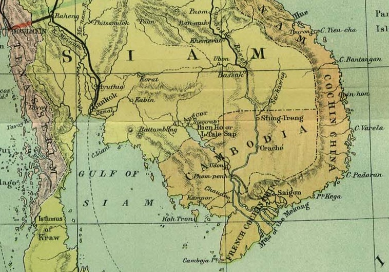
| Pagladawan | Detail showing Cambodia from map of French Indochina | ||||
| Petsa | |||||
| Pinagkunan | Crop of Image:Indochina_map_1886.jpg | ||||
| Kagsurat | Scottish Geographical Magazine | ||||
| Pagtugot (Giraray na paggamit sa file) |
|
||||
Kasaysayan kan file
Pinduton an sarong petsa/oras para mahiling ng file sa puntong idto.
| Petsa/Oras | Thumbnail | Sukol | Paragamit | Komento | |
|---|---|---|---|---|---|
| presente | 02:59, 2 Mayo 2008 | | 758 × 529 (197 KB) | Calliopejen1 | {{Information |Description=Detail showing Cambodia from map of French Indochina |Source=Crop of Image:Indochina_map_1886.jpg |Date=1886 |Author=Scottish Geographical Magazine |Permission={{PD-old}} |other_versions= }} [[Category:Maps of the history o |
Paggamit sa file
Mayong pahinang naggagamit sa file na ini.
Pankinaban na paggamit sa file
Ginagamit kan mga minasunod na wiki an file na ini:
- Paggamit sa arz.wikipedia.org
- Paggamit sa bat-smg.wikipedia.org
- Paggamit sa be-tarask.wikipedia.org
- Paggamit sa beta.wikiversity.org
- Paggamit sa bxr.wikipedia.org
- Paggamit sa cv.wikipedia.org
- Paggamit sa da.wikisource.org
- Paggamit sa de.wikipedia.org
- Paggamit sa de.wikisource.org
- Paggamit sa de.wikiversity.org
- Paggamit sa en.wikipedia.org
- Paggamit sa en.wikisource.org
- Paggamit sa en.wikivoyage.org
- Paggamit sa eo.wikipedia.org
- Paggamit sa es.wikibooks.org
- Paggamit sa es.wikinews.org
- Paggamit sa es.wikisource.org
- Paggamit sa fiu-vro.wikipedia.org
- Paggamit sa fi.wiktionary.org
- Paggamit sa frr.wikipedia.org
- Paggamit sa fr.wikipedia.org
- Paggamit sa fr.wikibooks.org
- Paggamit sa fr.wikinews.org
- Paggamit sa fr.wikiquote.org
- Paggamit sa fr.wikisource.org
- Paggamit sa fr.wikiversity.org
- Paggamit sa fr.wiktionary.org
- Paggamit sa fy.wikipedia.org
- Paggamit sa gu.wikipedia.org
- Paggamit sa gv.wikipedia.org
- Paggamit sa haw.wikipedia.org
- Paggamit sa hsb.wikipedia.org
- Paggamit sa hy.wikipedia.org
- Paggamit sa ia.wikipedia.org
- Paggamit sa ie.wikipedia.org
- Paggamit sa ig.wikipedia.org
- Paggamit sa incubator.wikimedia.org
- Paggamit sa io.wikipedia.org
- Paggamit sa is.wikipedia.org
- Paggamit sa it.wikipedia.org
- Paggamit sa it.wikinews.org
- Paggamit sa it.wikisource.org
- Paggamit sa ja.wikipedia.org
- Paggamit sa ja.wiktionary.org
- Paggamit sa ka.wikipedia.org
- Paggamit sa kk.wikipedia.org
- Paggamit sa kl.wikipedia.org
Hilingon an kadagdagan na pankinaban na paggamit sa file na ini.