
Ladawan:Map of India WV.svg

Size of this PNG preview of this SVG file: 513 × 599 na pixel. Ibang mga resolusyon: 205 × 240 na pixel | 411 × 480 na pixel | 658 × 768 na pixel | 877 × 1,024 na pixel | 1,754 × 2,048 na pixel | 1,251 × 1,461 na pixel.
Orihinal na file (SVG na file, nominal na 1,251 × 1,461 (na) pixel, pakadakula: 923 KB)
Sumaryo
| Pagladawan |
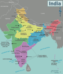
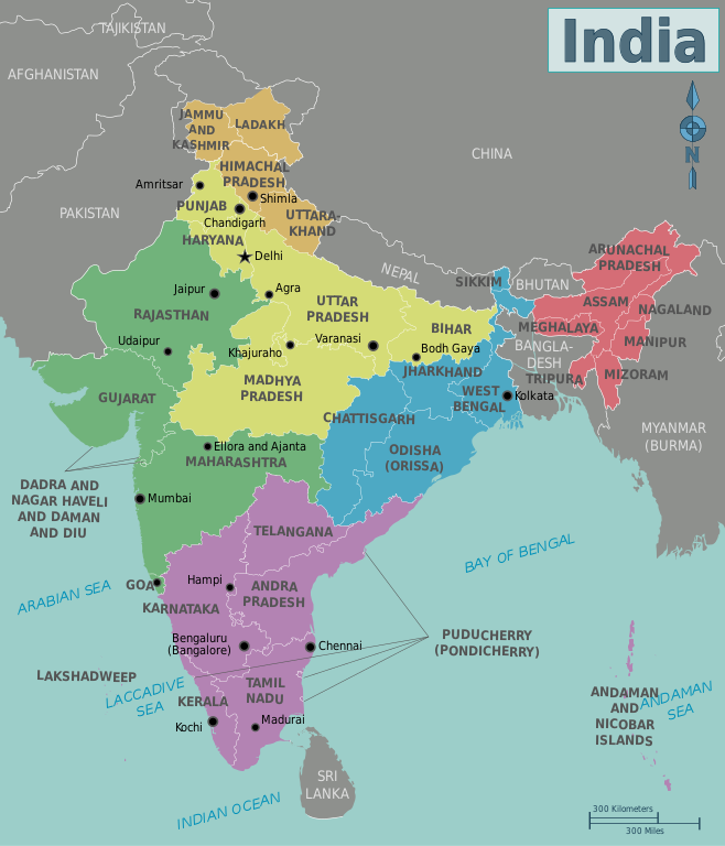
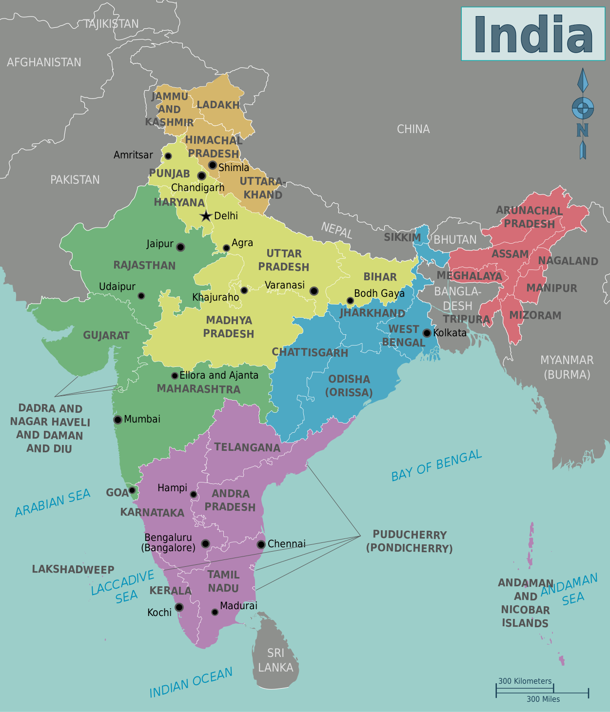
English: Map of India. A map of India's regions, states and metropolis', India
|
| Petsa | |
| Pinagkunan | Own work based on: India-states-numbered.svg |
| Kagsurat | Cacahuate, Ravikiran Rao, Nichalp (base outline) |
| Other versions |
PNG versions: |
| SVG genesis |

.png)
.png)
Paglisensya
This file is licensed under the Creative Commons Attribution-Share Alike Attribution-Share Alike 4.0 International, 3.0 Unported, 2.5 Generic, 2.0 Generic and 1.0 Generic license.
- Talingkas mo ining:
- maihiras – makokopya, maipapanao, asin maipapahiling an gibo
- i-remix – ma-adapt an gibo
- Sa irarom kan mga kondisyon na ini:
- atribusyon – Dapat mong i-credit, itao an link kan lisensya, at itukdo kun may binago ini. Pwede mo ining gibuhon sa dawa anong rasonableng paagi, pero bako sa paaging ineendorso ka o an paggamit mo kan naglisensya.
- share alike – Kun ire-remix mo, babaguhon, o madagdag sa materyal, kaipuhan mong ipanao an mga ambag mo sa irarom kan parehas o katulad na lisensya.
| Warning! According to Indian law, it is illegal to produce maps that in the view of the Indian government, misrepresent Indian territories by showing areas the Indian government claims ownership of but does not control as not belonging to India or as being contested. |
Original upload log
| This file was imported from Wikivoyage WTS. |
The original description page was here. All following user names refer to wts.wikivoyage-old.
- 2009-08-22 20:29 (WT-shared) Cacahuate[dead link] 744×1052 (934778 bytes) == Summary == {{Imagecredit|credit=[[User:Cacahuate|Cacahuate]], [[User:Mark|Mark]] (WT logo), [[:commons:User:Nichalp|Nichalp]] (base outli (Import from wikitravel.org/shared)
- 2009-08-25 05:42 (WT-shared) Ravikiranr[dead link] 744×1052 (957587 bytes) (Import from wikitravel.org/shared)
- 2009-08-25 20:07 (WT-shared) Cacahuate[dead link] 744×1052 (931860 bytes) Update fonts to DejaVu Sans Condensed (Import from wikitravel.org/shared)
- 2011-10-22 23:00 (WT-shared) Joelf[dead link] 1251×1461 (868042 bytes) +fr (Import from wikitravel.org/shared)
- 2012-09-11 16:18 Atsirlin[dead link] 1251×1461 (951593 bytes) +ru, cleanup
Kasaysayan kan file
Pinduton an sarong petsa/oras para mahiling ng file sa puntong idto.
| Petsa/Oras | Thumbnail | Sukol | Paragamit | Komento | |
|---|---|---|---|---|---|
| presente | 14:38, 16 Enero 2021 | | 1,251 × 1,461 (923 KB) | Sbb1413 | Updated to include new jurisdictions, plus the addition of union territories. |
| 12:58, 25 Enero 2016 |  | 1,251 × 1,461 (939 KB) | Csyogi | Telangana state update | |
| 10:16, 15 Disyembre 2013 |  | 1,251 × 1,461 (931 KB) | Saqib | typo | |
| 22:14, 8 Hunyo 2013 |  | 1,251 × 1,461 (931 KB) | Saqib | removed hatching | |
| 18:05, 15 Disyembre 2012 |  | 1,251 × 1,461 (929 KB) | OgreBot | (BOT): Reverting to most recent version before archival | |
| 18:04, 15 Disyembre 2012 |  | 1,251 × 1,461 (848 KB) | OgreBot | (BOT): Uploading old version of file from wts.wikivoyage; originally uploaded on 2011-10-22 23:00:45 by (WT-shared) Joelf | |
| 18:04, 15 Disyembre 2012 |  | 744 × 1,052 (910 KB) | OgreBot | (BOT): Uploading old version of file from wts.wikivoyage; originally uploaded on 2009-08-25 20:07:33 by (WT-shared) Cacahuate | |
| 18:04, 15 Disyembre 2012 |  | 744 × 1,052 (935 KB) | OgreBot | (BOT): Uploading old version of file from wts.wikivoyage; originally uploaded on 2009-08-25 05:42:19 by (WT-shared) Ravikiranr | |
| 18:04, 15 Disyembre 2012 |  | 744 × 1,052 (913 KB) | OgreBot | (BOT): Uploading old version of file from wts.wikivoyage; originally uploaded on 2009-08-22 20:29:43 by (WT-shared) Cacahuate | |
| 21:52, 25 Nobyembre 2012 |  | 1,251 × 1,461 (929 KB) | MGA73bot2 | {{BotMoveToCommons|wts.oldwikivoyage|year={{subst:CURRENTYEAR}}|month={{subst:CURRENTMONTHNAME}}|day={{subst:CURRENTDAY}}}} == {{int:filedesc}} == {{Information |description=Map of India. A map of India's regions, states and metropolis', India * Map of... |
Paggamit sa file
Mayong pahinang naggagamit sa file na ini.
Pankinaban na paggamit sa file
Ginagamit kan mga minasunod na wiki an file na ini:
- Paggamit sa en.wikipedia.org
- Paggamit sa nl.wikivoyage.org