
Ladawan:Abu Reyhan Biruni-Earth Circumference.svg

Orihinal na file (SVG na file, nominal na 1,000 × 900 (na) pixel, pakadakula: 16 KB)
Sumaryo
| Pagladawan |
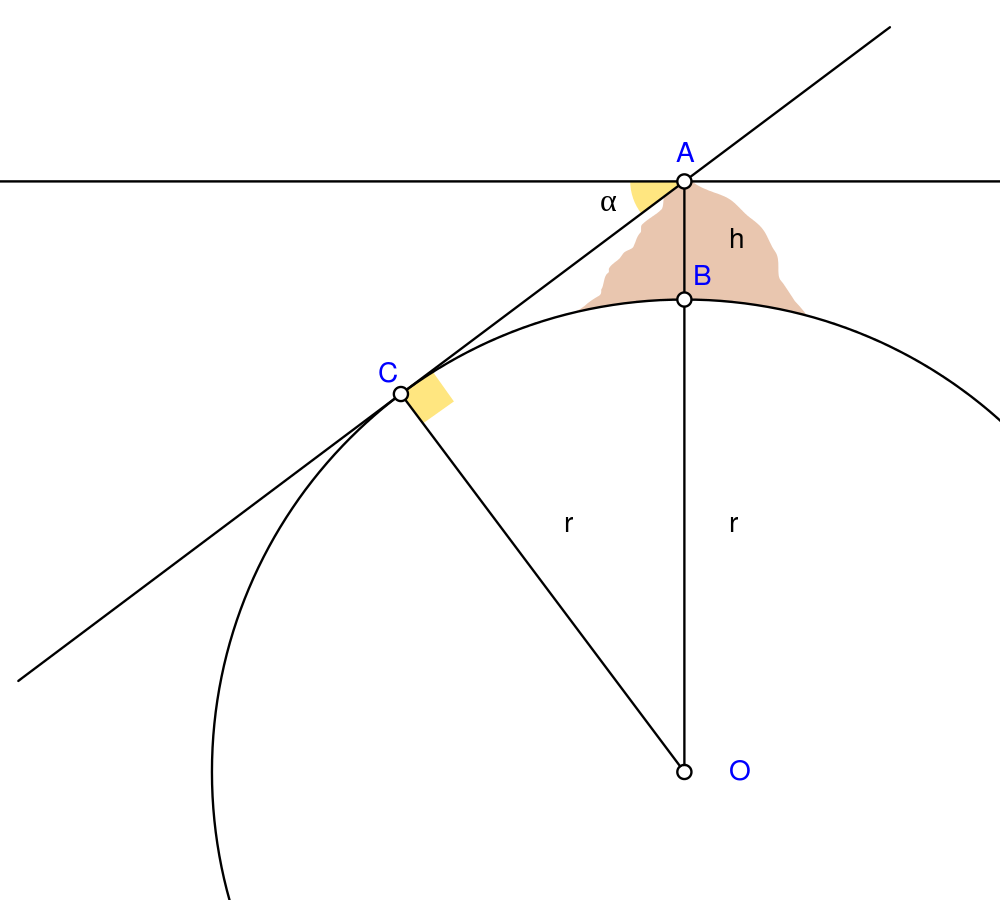
English: Biruni (973 - 1048) developed a new method using trigonometric calculations to compute earth's radius and circumference based on the angle between the horizontal line and true horizon from a mountain top with known height. He calculated the height of the mountain by going to two points at sea level with a known distance apart and then measuring the angle between the plain and the top of the mountain for both points.
Biruni's estimate of 6,339.9 km for the Earth radius had an error of 0.0026 and was 16.8 km less than the current value of 6,356.7 km. The idea came to him when he was on top of a tall mountain near Nandana in Pakistan. He measured the dip angle using an astrolabe and he applied to the law of sines formula. He also made use of algebra in his calculation.
Solution: Français : Biruni (973-1048) développa une nouvelle méthode utilisant la trigonométrie pour calculer le rayon et la ciconférence de la Terre, basée sur l'angle entre la ligne horizontale et l'horizon réel depuis le sommet d'une montagne de hauteur connue. Il calcula la hauteur de la montagne en se rendant en deux points situés au niveau de la mer dont l'écartement était connu, puis en mesurant l'angle entre la ligne horizontale formée par les deux points au niveau de la mer et le sommet de la montagne, et ceci depuis chacun des deux points.
L'estimation de Biruni de 6 339,9 km pour le rayon de la Terre comportait une erreur de 0,26 %, soit une valeur inférieure de 16,8 km par rapport à la valeur actuelle de 6 356,7 km. L'idée lui était venue alors qu'il se trouvait au sommet d'une haute montagne, près de Nandana en Inde. Il mesura l'angle d'incinaison avec un astrolabe et il appliqua la formule des sinus. Il fit également usage de l'algèbre pour ses calculs.
Solution : |
| Petsa | |
| Pinagkunan | Sadiring gibo Using Geogebra and Inkscape |
| Kagsurat | Nevit Dilmen |
| SVG genesis | and with GeoGebra. |
Paglisensya
- Talingkas mo ining:
- maihiras – makokopya, maipapanao, asin maipapahiling an gibo
- i-remix – ma-adapt an gibo
- Sa irarom kan mga kondisyon na ini:
- atribusyon – Dapat mong i-credit, itao an link kan lisensya, at itukdo kun may binago ini. Pwede mo ining gibuhon sa dawa anong rasonableng paagi, pero bako sa paaging ineendorso ka o an paggamit mo kan naglisensya.
- share alike – Kun ire-remix mo, babaguhon, o madagdag sa materyal, kaipuhan mong ipanao an mga ambag mo sa irarom kan parehas o katulad na lisensya.
Kasaysayan kan file
Pinduton an sarong petsa/oras para mahiling ng file sa puntong idto.
| Petsa/Oras | Thumbnail | Sukol | Paragamit | Komento | |
|---|---|---|---|---|---|
| presente | 05:25, 2 Mayo 2010 | | 1,000 × 900 (16 KB) | Nevit | Crop |
| 05:21, 2 Mayo 2010 |  | 1,390 × 1,220 (16 KB) | Nevit | Yellow removed | |
| 05:19, 2 Mayo 2010 |  | 1,390 × 1,220 (16 KB) | Nevit | Image version | |
| 05:18, 2 Mayo 2010 |  | 640 × 480 (22 KB) | Nevit | {{Information |Description={{en|1=Biruni (973 - 1048) developed a new method using trigonometric calculations to compute earth's circumference based on the angle between the horizontal line and true horizon from a mountain top with known height. He calcu |
Paggamit sa file
Ginagamit kan minasunod na pahina an file na ini:
Pankinaban na paggamit sa file
Ginagamit kan mga minasunod na wiki an file na ini:
- Paggamit sa af.wikipedia.org
- Paggamit sa ar.wikipedia.org
- Paggamit sa bn.wikipedia.org
- Paggamit sa bs.wikipedia.org
- Paggamit sa diq.wikipedia.org
- Paggamit sa en.wikipedia.org
- Paggamit sa es.wikipedia.org
- Paggamit sa fa.wikipedia.org
- Paggamit sa fr.wikipedia.org
- Paggamit sa he.wikipedia.org
- Paggamit sa hr.wikipedia.org
- Paggamit sa id.wikipedia.org
- Paggamit sa it.wikipedia.org
- Paggamit sa ja.wikipedia.org
- Paggamit sa ps.wikipedia.org
- Paggamit sa pt.wikipedia.org
- Paggamit sa pt.wikibooks.org
- Paggamit sa ro.wikipedia.org
- Paggamit sa ru.wikipedia.org
- Paggamit sa sd.wikipedia.org
- Paggamit sa sh.wikipedia.org
- Paggamit sa sr.wikipedia.org
- Paggamit sa ta.wikipedia.org
- Paggamit sa tr.wikipedia.org
- Paggamit sa tt.wikipedia.org
- Paggamit sa uk.wikipedia.org
- Paggamit sa uz.wikipedia.org
- Paggamit sa www.wikidata.org
Hilingon an kadagdagan na pankinaban na paggamit sa file na ini.