
Ladawan:Don Salvador Benedicto mountain range.jpg

Pakadakula kan pasirip na ini: 800 × 275 na pixel. Ibang mga resolusyon: 320 × 110 na pixel | 640 × 220 na pixel | 1,024 × 352 na pixel | 1,280 × 440 na pixel | 2,560 × 880 na pixel | 11,150 × 3,832 na pixel.
Orihinal na file (11,150 × 3,832 na pixel, pakadakula: 3.64 MB, tipo nin MIME: image/jpeg)
Sumaryo
| Pagladawan |
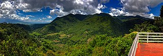
English: The municipality is a post-colonial provincial hill station, designated the Summer Capital of Negros Occidental, and is a popular tourist site.
Although a small town, the town of Don Salvador Benedicto has seen a rise in its municipal economy thanks to tourism and local agriculture. Due to its high altitude like Baguio, the town can support crops that grow in temperate areas, making it ideal for a multitude of farming businesses. Tourism is on the rise for the town especially when travellers head out into the heart of the province. Also located in the municipality are the Choco Hills, similar to Bohol's Chocolate Hills, with shared boundary of Barangay Prosperidad, San Carlos City. |
| Petsa | 29 Oktubre 2020, 11:32:31 (according to Exif data) |
| Pinagkunan | Sadiring gibo |
| Kagsurat | Austin Rex Lobaton |
| Camera location | | View this and other nearby images on: OpenStreetMap |
|---|
Paglisensya
I, the copyright holder of this work, hereby publish it under the following license:
This file is licensed under the Creative Commons Attribution-Share Alike 4.0 International license.
- Talingkas mo ining:
- maihiras – makokopya, maipapanao, asin maipapahiling an gibo
- i-remix – ma-adapt an gibo
- Sa irarom kan mga kondisyon na ini:
- atribusyon – Dapat mong i-credit, itao an link kan lisensya, at itukdo kun may binago ini. Pwede mo ining gibuhon sa dawa anong rasonableng paagi, pero bako sa paaging ineendorso ka o an paggamit mo kan naglisensya.
- share alike – Kun ire-remix mo, babaguhon, o madagdag sa materyal, kaipuhan mong ipanao an mga ambag mo sa irarom kan parehas o katulad na lisensya.
This image was uploaded as part of Wiki Loves Earth 2021.
|
 |
Kasaysayan kan file
Pinduton an sarong petsa/oras para mahiling ng file sa puntong idto.
| Petsa/Oras | Thumbnail | Sukol | Paragamit | Komento | |
|---|---|---|---|---|---|
| presente | 14:16, 26 Hunyo 2021 | 11,150 × 3,832 (3.64 MB) | Likbatonboot | Uploaded own work with UploadWizard |
Paggamit sa file
Ginagamit kan minasunod na pahina an file na ini:
Pankinaban na paggamit sa file
Ginagamit kan mga minasunod na wiki an file na ini:
- Paggamit sa en.wikipedia.org
- Paggamit sa incubator.wikimedia.org