
Ladawan:Fishermen at Dawki River.jpg
Pakadakula kan pasirip na ini: 800 × 533 na pixel. Ibang mga resolusyon: 320 × 213 na pixel | 640 × 427 na pixel | 1,024 × 683 na pixel | 1,280 × 853 na pixel | 2,560 × 1,707 na pixel | 5,184 × 3,456 na pixel.
Orihinal na file (5,184 × 3,456 na pixel, pakadakula: 7.29 MB, tipo nin MIME: image/jpeg)
Sumaryo
| Pagladawan |
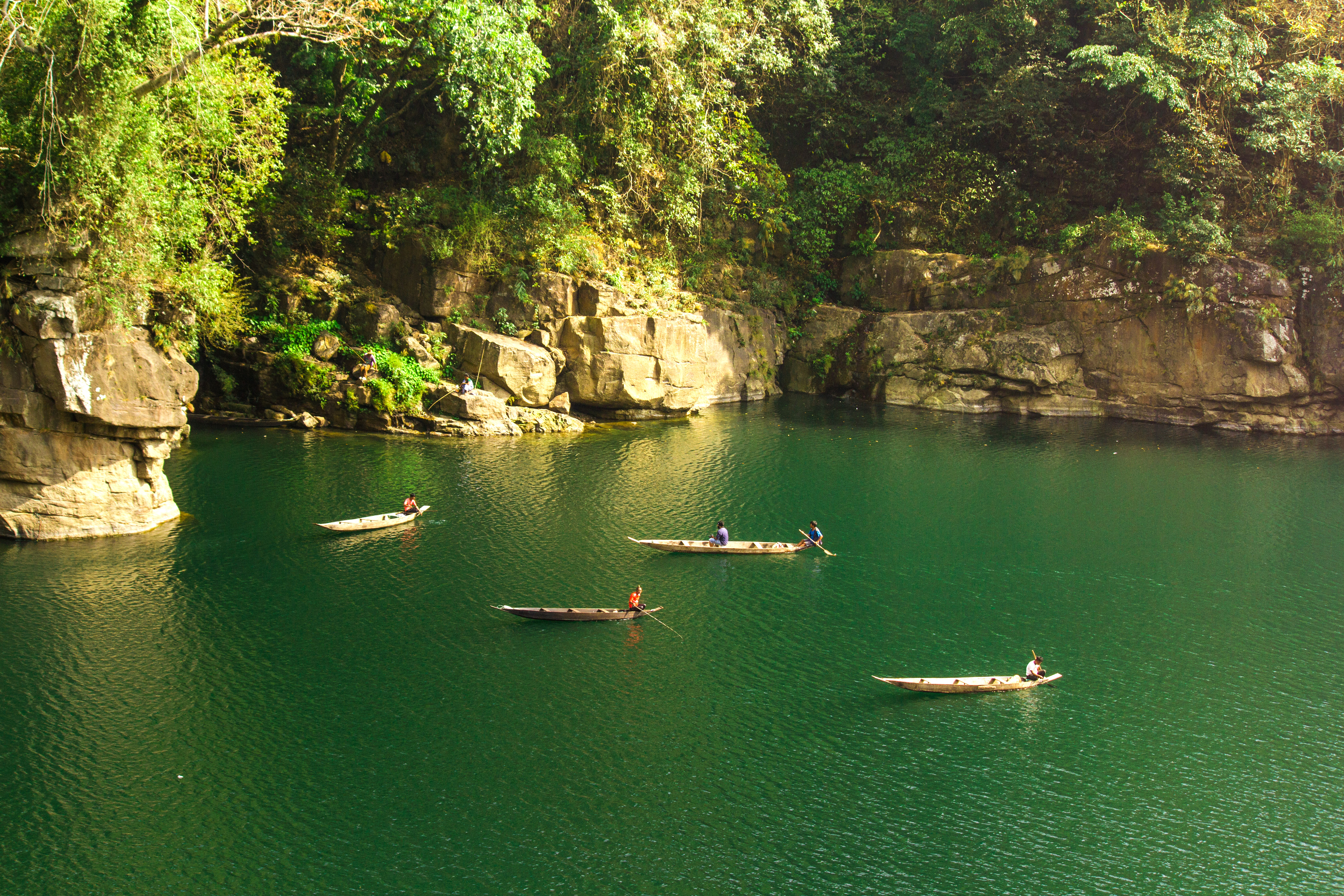
English: Along the border of India-Bangladesh, near the Tamabil-Dawki checkpost flows the beautiful Dawki river with greenish-blueish water so clear that one can see the bottom of the river even from as high as the bridge over the river. It flows very close to the customs checkpost at Dawki with Jaintia Hills District on one side and East Khasi Hills District on the other. As it enters the plains of Bangladesh it loses its beautiful color and becomes heavily strewn with rocks and small boulders. Local fishermen give boat rides to people visiting the area and sing songs while rowing he boat.
Located at the end of the Guwahati-Shillong-Dawki Road, Dawki is a small town well known for its sweet, juicy orange markets. I took the photograph from a hill, near the beautiful suspension bridge (built by the British colonial rulers before India's independence). |
| Petsa | |
| Pinagkunan | Sadiring gibo |
| Kagsurat | AditiVerma2193 |
| Camera location | | View this and other nearby images on: OpenStreetMap |
|---|
Paglisensya
I, the copyright holder of this work, hereby publish it under the following license:
This file is licensed under the Creative Commons Attribution-Share Alike 4.0 International license.
- Talingkas mo ining:
- maihiras – makokopya, maipapanao, asin maipapahiling an gibo
- i-remix – ma-adapt an gibo
- Sa irarom kan mga kondisyon na ini:
- atribusyon – Dapat mong i-credit, itao an link kan lisensya, at itukdo kun may binago ini. Pwede mo ining gibuhon sa dawa anong rasonableng paagi, pero bako sa paaging ineendorso ka o an paggamit mo kan naglisensya.
- share alike – Kun ire-remix mo, babaguhon, o madagdag sa materyal, kaipuhan mong ipanao an mga ambag mo sa irarom kan parehas o katulad na lisensya.
This image was uploaded as part of Wiki Loves Earth 2016.
|
 |
Kasaysayan kan file
Pinduton an sarong petsa/oras para mahiling ng file sa puntong idto.
| Petsa/Oras | Thumbnail | Sukol | Paragamit | Komento | |
|---|---|---|---|---|---|
| presente | 09:56, 3 Hunyo 2016 | | 5,184 × 3,456 (7.29 MB) | AditiVerma2193 | User created page with UploadWizard |
Paggamit sa file
Ginagamit kan minasunod na pahina an file na ini:
Pankinaban na paggamit sa file
Ginagamit kan mga minasunod na wiki an file na ini:
- Paggamit sa bn.wikipedia.org
- Paggamit sa en.wikipedia.org
- Paggamit sa id.wikipedia.org