
Ladawan:Greater East Asia Conference Map.PNG
Pakadakula kan pasirip na ini: 800 × 370 na pixel. Ibang mga resolusyon: 320 × 148 na pixel | 640 × 296 na pixel | 1,357 × 628 na pixel.
Orihinal na file (1,357 × 628 na pixel, pakadakula: 40 KB, tipo nin MIME: image/png)
Sumaryo
| Pagladawan |
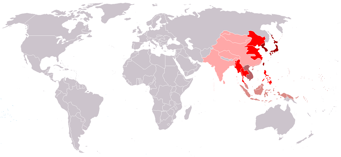
English: Countries - members of the Greater East Asia Conference |
| Petsa | |
| Pinagkunan | Sadiring gibo |
| Kagsurat | Makakaaaa |
Japanese empire (host country)
Countries-members of the Greater East Asia Conference
Disputed territories
Paglisensya
I, the copyright holder of this work, hereby publish it under the following licenses:
Nakalisensya an file na ini sa irarom kan lisensyang Creative Commons Attribution-Share Alike 3.0 Unported.
- Talingkas mo ining:
- maihiras – makokopya, maipapanao, asin maipapahiling an gibo
- i-remix – ma-adapt an gibo
- Sa irarom kan mga kondisyon na ini:
- atribusyon – Dapat mong i-credit, itao an link kan lisensya, at itukdo kun may binago ini. Pwede mo ining gibuhon sa dawa anong rasonableng paagi, pero bako sa paaging ineendorso ka o an paggamit mo kan naglisensya.
- share alike – Kun ire-remix mo, babaguhon, o madagdag sa materyal, kaipuhan mong ipanao an mga ambag mo sa irarom kan parehas o katulad na lisensya.

|
Tinutugutan an pagkopya, pagpanao, asin/o pagbago sa dokumentong ini sa irarom kan mga termino kan GNU Free Documentation License, Bersyon 1.2 o dawa anong mas bagong bersyon na naipublikar kan Free Software Foundation; na mayong paburubagong seksyon, mayong teksto sa front-cover, asin walang teksto sa back-cover. Igwang nakalaag na kopya kan lisensya sa seksyon na may titulong GNU Free Documentation License. |
Pwede kang makapili nin lisensya mo.
Kasaysayan kan file
Pinduton an sarong petsa/oras para mahiling ng file sa puntong idto.
| Petsa/Oras | Thumbnail | Sukol | Paragamit | Komento | |
|---|---|---|---|---|---|
| presente | 16:57, 27 Abril 2020 | | 1,357 × 628 (40 KB) | Paul 012 | Reverting changes - unreferenced; the eastern Pacific areas were never seriously considered |
| 19:14, 2 Marso 2020 |  | 1,357 × 628 (54 KB) | Satoshi Kondo | 大東亞共榮圈 | |
| 13:43, 28 Agosto 2013 |  | 1,357 × 628 (40 KB) | Elmor | Wang Jingwei regime never made statements recognising independence of Mongolia, Tibet, or Tuva | |
| 12:04, 16 Abril 2011 |  | 1,357 × 628 (26 KB) | Elmor | proper German borders | |
| 18:29, 12 Abril 2011 |  | 1,357 × 628 (47 KB) | Lpi4635 | correcting mistake | |
| 20:42, 10 Abril 2011 |  | 1,357 × 628 (47 KB) | Lpi4635 | corrected mistakes | |
| 11:50, 2 Abril 2011 |  | 1,357 × 628 (47 KB) | Lpi4635 | Northern Sakhalin was not the part of Japanese Empire | |
| 21:46, 26 Marso 2011 |  | 1,357 × 628 (47 KB) | Lpi4635 | {{Information |Description ={{en|1=Countries - members of the Greater East Asia Conference}} |Source =own work |Author =Makakaaaa |Date =2011-03-27 |Permission = |other_versions =no }} |
Paggamit sa file
Ginagamit kan minasunod na pahina an file na ini:
Pankinaban na paggamit sa file
Ginagamit kan mga minasunod na wiki an file na ini:
- Paggamit sa ar.wikipedia.org
- Paggamit sa be.wikipedia.org
- Paggamit sa en.wikipedia.org
- Paggamit sa fa.wikipedia.org
- Paggamit sa fr.wikipedia.org
- Paggamit sa he.wikipedia.org
- Paggamit sa it.wikipedia.org
- Paggamit sa ja.wikipedia.org
- Paggamit sa pl.wikipedia.org
- Paggamit sa pt.wikipedia.org
- Paggamit sa ru.wikipedia.org
- Paggamit sa tl.wikipedia.org
- Paggamit sa uk.wikipedia.org
- Paggamit sa zh.wikipedia.org