
Ladawan:Hunter gatherer's camp at Irish National Heritage Park - geograph.org.uk - 1252699.jpg

Pakadakula kan pasirip na ini: 800 × 600 na pixel. Ibang mga resolusyon: 320 × 240 na pixel | 640 × 480 na pixel | 1,024 × 768 na pixel | 1,280 × 960 na pixel | 1,600 × 1,200 na pixel.
Orihinal na file (1,600 × 1,200 na pixel, pakadakula: 442 KB, tipo nin MIME: image/jpeg)
Sumaryo
| Pagladawan |
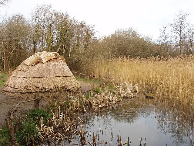
English: Hunter gatherer's camp at Irish National Heritage Park Exhibit showing how a 7000 B.C. campsite of Mesolithic period hunter gatherers would have looked. They were nomadic and built temporary houses. Wood, bone and flint were the materials of their tools. They fished using dugout canoes - there is one in the photo.
More photos in the park, see https://www.geograph.org.uk/gallery/irish_national_heritage_park_county_wexford_10033 . |
| Petsa | |
| Pinagkunan | From geograph.org.uk |
| Kagsurat | David Hawgood |
| Atribusyon (required by the license) | David Hawgood / Hunter gatherer's camp at Irish National Heritage Park / |
| Camera location | | View this and other nearby images on: OpenStreetMap |
|---|
_heading:135.00&language=bcl)
| Object location | | View this and other nearby images on: OpenStreetMap |
|---|
_heading:135.00&language=bcl)
Paglisensya

|
This image was taken from the Geograph project collection. See this photograph's page on the Geograph website for the photographer's contact details. The copyright on this image is owned by David Hawgood and is licensed for reuse under the Creative Commons Attribution-ShareAlike 2.0 license.
|
This file is licensed under the Creative Commons Attribution-Share Alike 2.0 Generic license.
Atribusyon: David Hawgood
- Talingkas mo ining:
- maihiras – makokopya, maipapanao, asin maipapahiling an gibo
- i-remix – ma-adapt an gibo
- Sa irarom kan mga kondisyon na ini:
- atribusyon – Dapat mong i-credit, itao an link kan lisensya, at itukdo kun may binago ini. Pwede mo ining gibuhon sa dawa anong rasonableng paagi, pero bako sa paaging ineendorso ka o an paggamit mo kan naglisensya.
- share alike – Kun ire-remix mo, babaguhon, o madagdag sa materyal, kaipuhan mong ipanao an mga ambag mo sa irarom kan parehas o katulad na lisensya.
Kasaysayan kan file
Pinduton an sarong petsa/oras para mahiling ng file sa puntong idto.
| Petsa/Oras | Thumbnail | Sukol | Paragamit | Komento | |
|---|---|---|---|---|---|
| presente | 21:41, 7 Setyembre 2017 | | 1,600 × 1,200 (442 KB) | Geograph Update Bot | Higher-resolution version from Geograph. |
| 20:15, 26 Pebrero 2011 |  | 640 × 480 (107 KB) | GeographBot | == {{int:filedesc}} == {{Information |description={{en|1=Hunter gatherer's camp at Irish National Heritage Park Exhibit showing how a 7000 B.C. campsite of Mesolithic period hunter gatherers would have looked. They were nomadic and built temporary houses. |
Paggamit sa file
Ginagamit kan minasunod na pahina an file na ini:
Pankinaban na paggamit sa file
Ginagamit kan mga minasunod na wiki an file na ini:
- Paggamit sa af.wikipedia.org
- Paggamit sa ar.wikipedia.org
- Paggamit sa azb.wikipedia.org
- Paggamit sa bs.wikipedia.org
- Paggamit sa ca.wikipedia.org
- Paggamit sa de.wikipedia.org
- Paggamit sa en.wikipedia.org
- Paggamit sa en.wikiquote.org
- Paggamit sa fi.wikipedia.org
- Paggamit sa fr.wikipedia.org
- Paggamit sa ga.wikipedia.org
- Paggamit sa lfn.wikipedia.org
- Paggamit sa nl.wikipedia.org
- Paggamit sa no.wikipedia.org
- Paggamit sa oc.wikipedia.org
- Paggamit sa ru.wikipedia.org
- Paggamit sa sr.wikipedia.org
- Paggamit sa szl.wikipedia.org
- Paggamit sa ta.wikipedia.org