
Ladawan:Kosovo map-en.svg

Size of this PNG preview of this SVG file: 582 × 599 na pixel. Ibang mga resolusyon: 233 × 240 na pixel | 466 × 480 na pixel | 746 × 768 na pixel | 994 × 1,024 na pixel | 1,989 × 2,048 na pixel | 1,777 × 1,830 na pixel.
Orihinal na file (SVG na file, nominal na 1,777 × 1,830 (na) pixel, pakadakula: 3.81 MB)
Sumaryo
| Description |
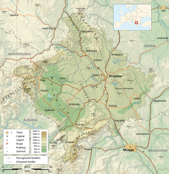
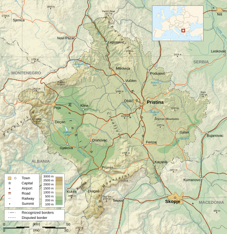
Čeština: Mapa Kosova. Dansk: Kort over Kosovo. Deutsch: Karte des Kosovo. English: Map of the Kosovo. Español: Mapa de Kosovo. Français : Carte du Kosovo, en anglais. Italiano: Mappa del Kosovo. Magyar: Koszovó térképe albán és szerb helységnevekkel. Polski: Mapa Kosowa. Română: Harta provinciei Kosovo Svenska: Karta över Kosovo, engelskspråkig. Türkçe: Kosova haritası. Македонски: Карта на Косово на англиски. Русский: Карта Косово, на английском. Українська: Карта Косово 日本語: コソボの地図。 |
||||||
| Petsa | |||||||
| Pinagkunan |
Own work. Sources :
Software used :
Other data :
|
||||||
| Creator | |||||||
| Georeferencing | If inappropriate please set warp_status = skip to hide. | ||||||
| Other versions |
[] | ||||||
| Atribusyon (required by the license) | © Sémhur / Wikimedia Commons / | ||||||
| Assessments |
|
||||||
| SVG | W3C-validity not checked.
|
||||||
| Graphic Lab |


| Camera location | | View this and other nearby images on: OpenStreetMap |
|---|
Paglisensya
I, the copyright holder of this work, hereby publish it under the following licenses:
| Copyleft: This work of art is free; you can redistribute it and/or modify it according to terms of the Free Art License. You will find a specimen of this license on the Copyleft Attitude site as well as on other sites. |
This file is licensed under the Creative Commons Attribution-Share Alike 4.0 International, 3.0 Unported, 2.5 Generic, 2.0 Generic and 1.0 Generic license.
- Talingkas mo ining:
- maihiras – makokopya, maipapanao, asin maipapahiling an gibo
- i-remix – ma-adapt an gibo
- Sa irarom kan mga kondisyon na ini:
- atribusyon – Dapat mong i-credit, itao an link kan lisensya, at itukdo kun may binago ini. Pwede mo ining gibuhon sa dawa anong rasonableng paagi, pero bako sa paaging ineendorso ka o an paggamit mo kan naglisensya.
- share alike – Kun ire-remix mo, babaguhon, o madagdag sa materyal, kaipuhan mong ipanao an mga ambag mo sa irarom kan parehas o katulad na lisensya.
Pwede kang makapili nin lisensya mo.
Kasaysayan kan file
Pinduton an sarong petsa/oras para mahiling ng file sa puntong idto.
| Petsa/Oras | Thumbnail | Sukol | Paragamit | Komento | |
|---|---|---|---|---|---|
| presente | 14:35, 21 Setyembre 2023 | | 1,777 × 1,830 (3.81 MB) | Socialdilema | File uploaded using svgtranslate tool (https://svgtranslate.toolforge.org/). Added translation for ca. |
| 18:41, 12 Mayo 2021 |  | 1,777 × 1,830 (3.74 MB) | Uniacademic | Same as the previous edit. | |
| 18:28, 12 Mayo 2021 |  | 1,777 × 1,830 (3.74 MB) | Uniacademic | Updated the names of cities in cases where WP:COMMONNAME has changed since 2008. | |
| 09:14, 5 Marso 2008 |  | 1,777 × 1,830 (3.75 MB) | Sémhur | Added borders, with keys (recognized - disputed) | |
| 09:16, 4 Marso 2008 |  | 1,777 × 1,830 (3.74 MB) | Sémhur | Remove Kosovo boundaries to neutralize the map, + labels more readable | |
| 14:45, 3 Marso 2008 |  | 1,777 × 1,830 (3.74 MB) | Sémhur | Correcting few labels | |
| 19:15, 28 Pebrero 2008 |  | 1,777 × 1,830 (3.74 MB) | Sémhur | minor changes | |
| 11:37, 26 Pebrero 2008 |  | 1,777 × 1,830 (3.74 MB) | Sémhur | == Description == {{Information |Description= {{en| Map of the Kosovo.}} {{fr| Carte du Kosovo, en anglais.}} |Source=Own work. {{clr}} Sources : * Topographic background : [http://www2.jpl.nasa.gov/srtm NASA Shuttle Radar To |
Paggamit sa file
Ginagamit kan minasunod na pahina an file na ini:
Pankinaban na paggamit sa file
Ginagamit kan mga minasunod na wiki an file na ini:
- Paggamit sa af.wikipedia.org
- Paggamit sa ar.wikipedia.org
- Paggamit sa az.wikipedia.org
- Paggamit sa be-tarask.wikipedia.org
- Paggamit sa bg.wikipedia.org
- Paggamit sa de.wikipedia.org
- Paggamit sa de.wikibooks.org
- Paggamit sa en.wikipedia.org
- Paggamit sa es.wikipedia.org
- Paggamit sa fa.wikipedia.org
- Paggamit sa fi.wikipedia.org
- Paggamit sa fr.wikipedia.org
- Paggamit sa fr.wikinews.org
- Paggamit sa ga.wikipedia.org
- Paggamit sa gl.wikipedia.org
- Paggamit sa gv.wikipedia.org
- Paggamit sa hy.wikipedia.org
- Paggamit sa is.wikipedia.org
- Paggamit sa ko.wikipedia.org
- Paggamit sa lt.wikipedia.org
- Paggamit sa mg.wikipedia.org
- Paggamit sa ml.wikipedia.org
- Paggamit sa mr.wikipedia.org
- Paggamit sa mzn.wikipedia.org
- Paggamit sa nn.wikipedia.org
- Paggamit sa no.wikipedia.org
- Paggamit sa pa.wikipedia.org
Hilingon an kadagdagan na pankinaban na paggamit sa file na ini.