
Ladawan:Ph Territorial Map.png

Pakadakula kan pasirip na ini: 584 × 600 na pixel. Ibang mga resolusyon: 234 × 240 na pixel | 467 × 480 na pixel | 748 × 768 na pixel | 997 × 1,024 na pixel | 1,827 × 1,877 na pixel.
Orihinal na file (1,827 × 1,877 na pixel, pakadakula: 612 KB, tipo nin MIME: image/png)

|
This map image could be re-created using vector graphics as an SVG file. This has several advantages; see Commons:Media for cleanup for more information. If an SVG form of this image is available, please upload it and afterwards replace this template with
{{vector version available|new image name}}.
It is recommended to name the SVG file “Ph Territorial Map.svg”—then the template Vector version available (or Vva) does not need the new image name parameter. |
Sumaryo
| Pagladawan |
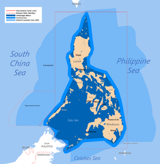
English: Territorial map claimed by the Philippines, showing internal waters, territorial sea, international treaty limits and exclusive economic zone. |
| Petsa | 25 Hunyo 2007 (original upload) |
| Pinagkunan | English Wikipedia (log) |
| Kagsurat | Roel Balingit (username: Namayan); addition of Benham Rise and Indo-PH EEZs: Ervin Malicdem (schadow1) |
Paglisensya
Roel Balingit (username: Namayan), the copyright holder of this work, hereby publishes it under the following licenses:

|
Tinutugutan an pagkopya, pagpanao, asin/o pagbago sa dokumentong ini sa irarom kan mga termino kan GNU Free Documentation License, Bersyon 1.2 o dawa anong mas bagong bersyon na naipublikar kan Free Software Foundation; na mayong paburubagong seksyon, mayong teksto sa front-cover, asin walang teksto sa back-cover. Igwang nakalaag na kopya kan lisensya sa seksyon na may titulong GNU Free Documentation License. |
This file is licensed under the Creative Commons Attribution 2.5 Generic license.
Atribusyon: Roel Balingit (username: Namayan)
- Talingkas mo ining:
- maihiras – makokopya, maipapanao, asin maipapahiling an gibo
- i-remix – ma-adapt an gibo
- Sa irarom kan mga kondisyon na ini:
- atribusyon – Dapat mong i-credit, itao an link kan lisensya, at itukdo kun may binago ini. Pwede mo ining gibuhon sa dawa anong rasonableng paagi, pero bako sa paaging ineendorso ka o an paggamit mo kan naglisensya.
Pwede kang makapili nin lisensya mo.
Kasaysayan kan file
Pinduton an sarong petsa/oras para mahiling ng file sa puntong idto.
| Petsa/Oras | Thumbnail | Sukol | Paragamit | Komento | |
|---|---|---|---|---|---|
| presente | 05:58, 19 Hulyo 2015 | | 1,827 × 1,877 (612 KB) | Schadow1 | Extending EEZ boundaries to include Benham Rise Extended EEZ and Philippines-Indonesia EEZ Delimitation Agreement |
| 11:33, 8 Mayo 2012 |  | 1,827 × 1,790 (535 KB) | Sky Harbor | Reverted to version as of 16:54, 28 August 2009. The name "West Philippine Sea" is a neologism and is not neutral. | |
| 08:13, 4 Mayo 2012 |  | 612 × 600 (129 KB) | Jeromesandilanico | Change of name as West Philippine Sea as used to describe the Philippines official claim as used by the Philippine Government and Media. | |
| 16:54, 28 Agosto 2009 |  | 1,827 × 1,790 (535 KB) | Mormegil | {{Information |Description= {{en|Territorial map of the Philippines, showing internal waters, territorial sea, international treaty limits and exclusive economic zone.}} |Source=English Wikipedia |Date={{date|2007-0 |
Paggamit sa file
Mayong pahinang naggagamit sa file na ini.
Pankinaban na paggamit sa file
Ginagamit kan mga minasunod na wiki an file na ini:
- Paggamit sa af.wikipedia.org
- Paggamit sa bn.wikipedia.org
- Paggamit sa cs.wikipedia.org
- Paggamit sa de.wikipedia.org
- Paggamit sa en.wikipedia.org
- Scarborough Shoal
- User:Namayan
- Philippines and the Spratly Islands
- Wikipedia talk:Tambayan Philippines/Archive 16
- Spratly Islands dispute
- Wikipedia:Graphics Lab/Map workshop/Archive/Apr 2013
- Wikipedia:Graphics Lab/Map workshop/Archive/May 2014
- Baselines of the Philippines
- Borders of the Philippines
- User:TagaSanPedroAko/Original contents of Presidency of Rodrigo Duterte
- User:Jose Edmundo Dayot/PIL Module 4
- Paggamit sa fr.wikipedia.org
- Paggamit sa gl.wikipedia.org
- Paggamit sa he.wikipedia.org
- Paggamit sa he.wiktionary.org
- Paggamit sa ilo.wikipedia.org
- Paggamit sa io.wikipedia.org
- Paggamit sa it.wikipedia.org
- Paggamit sa ja.wikipedia.org
- Paggamit sa ka.wikipedia.org
- Paggamit sa km.wikipedia.org
- Paggamit sa kn.wikipedia.org
- Paggamit sa mdf.wikipedia.org
- Paggamit sa pa.wikipedia.org
- Paggamit sa pl.wikipedia.org
- Paggamit sa pnb.wikipedia.org
- Paggamit sa sk.wikipedia.org
- Paggamit sa th.wikipedia.org
- Paggamit sa tl.wikipedia.org
- Paggamit sa uk.wikipedia.org
Hilingon an kadagdagan na pankinaban na paggamit sa file na ini.