
Ladawan:TitanicRoute.png
Mayo na nin mas malinaw.
TitanicRoute.png (741 × 332 na pixel, pakadakula: 89 KB, tipo nin MIME: image/png)
Sumaryo
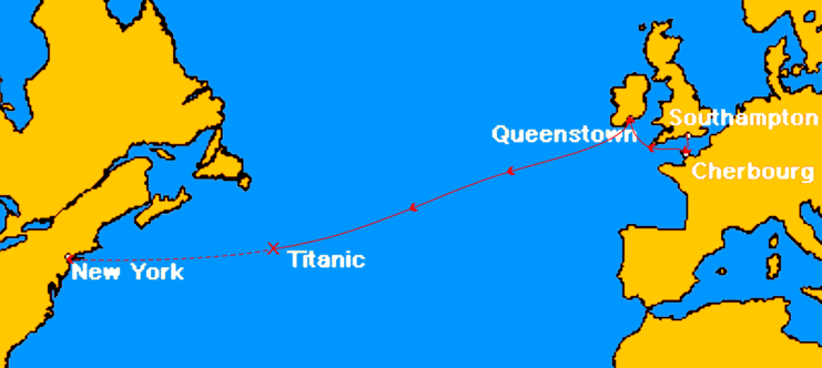
| Pagladawan | Map marks the route of Titanic during her maiden voyage, the ports on that route, and approximate location of where she sank. The remaining portion of her uncompleted route is shown dashed. | ||
| Pinagkunan | This image was created by en:User:MechBrowman using http://www.aquarius.geomar.de/omc/ and Paint Shop Pro and edited by en:User:Gary Joseph 23:05, 8 October 2006 (UTC) using Corel Draw 12. | ||
| Kagsurat | en:User:Gary Joseph and en:User:MechBrowman | ||
| Pagtugot (Giraray na paggamit sa file) |
|
||
| Other versions |
|

|
This incident map image could be re-created using vector graphics as an SVG file. This has several advantages; see Commons:Media for cleanup for more information. If an SVG form of this image is available, please upload it and afterwards replace this template with
{{vector version available|new image name}}.
It is recommended to name the SVG file “TitanicRoute.svg”—then the template Vector version available (or Vva) does not need the new image name parameter. |
Kasaysayan kan file
Pinduton an sarong petsa/oras para mahiling ng file sa puntong idto.
| Petsa/Oras | Thumbnail | Sukol | Paragamit | Komento | |
|---|---|---|---|---|---|
| presente | 18:16, 16 Enero 2012 | | 741 × 332 (89 KB) | Soerfm | Crop |
| 16:24, 31 Disyembre 2011 |  | 756 × 332 (91 KB) | Soerfm | Crop | |
| 15:03, 22 Pebrero 2007 |  | 800 × 332 (93 KB) | Nimbus08~commonswiki | {{Information |Description=Route du RMS Titanic en 1912 |Source=http://en.wikipedia.org/wiki/Image:TitanicRoute.png |Date=08/10/06 |Author=Gary Joseph |Permission= |other_versions= }} |
Paggamit sa file
Mayong pahinang naggagamit sa file na ini.
Pankinaban na paggamit sa file
Ginagamit kan mga minasunod na wiki an file na ini:
- Paggamit sa fr.wikipedia.org
- Paggamit sa ku.wikipedia.org
- Paggamit sa th.wikipedia.org
- Paggamit sa tr.wikipedia.org