
Ladawan:Ukraine under russian occupation.svg

Size of this PNG preview of this SVG file: 800 × 538 na pixel. Ibang mga resolusyon: 320 × 215 na pixel | 640 × 430 na pixel | 1,024 × 688 na pixel | 1,280 × 860 na pixel | 2,560 × 1,720 na pixel | 3,780 × 2,540 na pixel.
Orihinal na file (SVG na file, nominal na 3,780 × 2,540 (na) pixel, pakadakula: 1.85 MB)
Sumaryo
| Pagladawan |
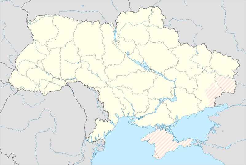
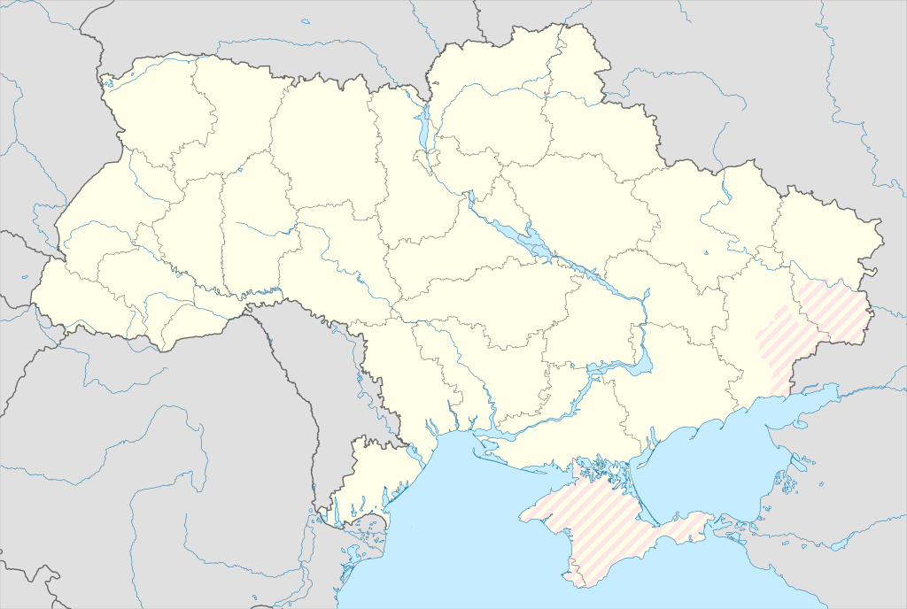
English: Location map of Ukraine under russian occupation.
Українська: Карта України з зонами російської окупації. |
| Petsa | |
| Pinagkunan |
Own work using: Ukraine adm location map improved.svg, according to
|
| Kagsurat | Yakiv Gluck |
| Other versions |
|
| SVG genesis | This locator map was created with Adobe Illustrator. |


Paglisensya
I, the copyright holder of this work, hereby publish it under the following license:
This file is licensed under the Creative Commons Attribution-Share Alike 4.0 International license.
- Talingkas mo ining:
- maihiras – makokopya, maipapanao, asin maipapahiling an gibo
- i-remix – ma-adapt an gibo
- Sa irarom kan mga kondisyon na ini:
- atribusyon – Dapat mong i-credit, itao an link kan lisensya, at itukdo kun may binago ini. Pwede mo ining gibuhon sa dawa anong rasonableng paagi, pero bako sa paaging ineendorso ka o an paggamit mo kan naglisensya.
- share alike – Kun ire-remix mo, babaguhon, o madagdag sa materyal, kaipuhan mong ipanao an mga ambag mo sa irarom kan parehas o katulad na lisensya.
Kasaysayan kan file
Pinduton an sarong petsa/oras para mahiling ng file sa puntong idto.
| Petsa/Oras | Thumbnail | Sukol | Paragamit | Komento | |
|---|---|---|---|---|---|
| presente | 02:45, 17 Mayo 2024 | | 3,780 × 2,540 (1.85 MB) | Physeters | add detail to dnipro delta |
| 15:45, 9 Agosto 2023 |  | 3,780 × 2,540 (1.36 MB) | Dƶoxar | Until the war ends it has no sense to maintain another map with actual frontline | |
| 09:32, 25 Hulyo 2023 |  | 3,780 × 2,540 (1.64 MB) | ASDFPM | Reverted to version as of 17:17, 3 October 2022 (UTC) | |
| 02:45, 12 Nobyembre 2022 |  | 3,780 × 2,540 (1.36 MB) | Qexypnos | Reverted to version as of 17:02, 3 March 2018 (UTC) | |
| 17:17, 3 Oktubre 2022 |  | 3,780 × 2,540 (1.64 MB) | Janitoalevic | Update | |
| 17:02, 3 Marso 2018 |  | 3,780 × 2,540 (1.36 MB) | Yakiv Gluck | improved using new adm loc map | |
| 01:08, 27 Enero 2018 |  | 1,546 × 1,038 (457 KB) | Yakiv Gluck | {{Information |Description ={{en|Location map of Ukraine under russian occupation.}} {{uk|Карта України з зонами російської окупації.}} |Source =own work, using [[:F... |
Paggamit sa file
Mayong pahinang naggagamit sa file na ini.
Pankinaban na paggamit sa file
Ginagamit kan mga minasunod na wiki an file na ini:
- Paggamit sa an.wikipedia.org
- Paggamit sa de.wikipedia.org
- Paggamit sa en.wikipedia.org
- Paggamit sa es.wikipedia.org
Hilingon an kadagdagan na pankinaban na paggamit sa file na ini.