
Ladawan:West Philippine Sea.svg

Size of this PNG preview of this SVG file: 384 × 599 na pixel. Ibang mga resolusyon: 154 × 240 na pixel | 307 × 480 na pixel | 492 × 768 na pixel | 656 × 1,024 na pixel | 1,313 × 2,048 na pixel | 507 × 791 na pixel.
Orihinal na file (SVG na file, nominal na 507 × 791 (na) pixel, pakadakula: 766 KB)
Sumaryo
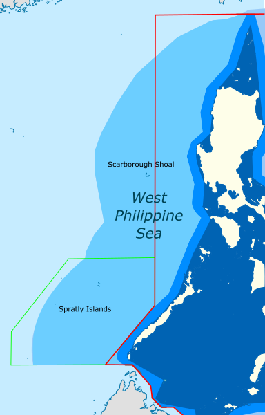
| Pagladawan | Map showing the area in the South China Sea which roughly correspond to the "West Philippine Sea" |
| Petsa | (UTC) |
| Pinagkunan |
This file was derived from: |
| Kagsurat |
|


| This is a retouched picture, which means that it has been digitally altered from its original version. The original can be viewed here: Ph Territorial Map.png:
|
Paglisensya
Nakalisensya an file na ini sa irarom kan lisensyang Creative Commons Attribution-Share Alike 3.0 Unported.
- Talingkas mo ining:
- maihiras – makokopya, maipapanao, asin maipapahiling an gibo
- i-remix – ma-adapt an gibo
- Sa irarom kan mga kondisyon na ini:
- atribusyon – Dapat mong i-credit, itao an link kan lisensya, at itukdo kun may binago ini. Pwede mo ining gibuhon sa dawa anong rasonableng paagi, pero bako sa paaging ineendorso ka o an paggamit mo kan naglisensya.
- share alike – Kun ire-remix mo, babaguhon, o madagdag sa materyal, kaipuhan mong ipanao an mga ambag mo sa irarom kan parehas o katulad na lisensya.
Original upload log
This image is a derivative work of the following images:
- File:South China Sea location map.svg licensed with Cc-by-sa-3.0, Cc-by-sa-3.0-de
- 2011-08-17T18:56:31Z NordNordWest 1134x1229 (631729 Bytes) == {{int:filedesc}} == {{Information |Description= {{de|Positionskarte des [[:de:Südchinesisches Meer|Südchinesischen Meers]]}} Quadratische Plattkarte, N-S-Streckung 102 %. Geographische Begrenzung der Karte: * N: 25.5° N
- File:Ph Territorial Map.png licensed with Cc-by-2.5, GFDL
- 2015-07-19T05:58:17Z Schadow1 1827x1877 (627018 Bytes) Extending EEZ boundaries to include Benham Rise Extended EEZ and Philippines-Indonesia EEZ Delimitation Agreement
- 2012-05-08T11:33:56Z Sky Harbor 1827x1790 (547714 Bytes) Reverted to version as of 16:54, 28 August 2009. The name "West Philippine Sea" is a neologism and is not neutral.
- 2012-05-04T08:13:30Z Jeromesandilanico 612x600 (131658 Bytes) Change of name as West Philippine Sea as used to describe the Philippines official claim as used by the Philippine Government and Media.
- 2009-08-28T16:54:58Z Mormegil 1827x1790 (547714 Bytes) {{Information |Description= {{en|Territorial map of the [[Philippines]], showing internal waters, territorial sea, international treaty limits and exclusive economic zone.}} |Source=[[:en:File:Ph Territorial Map.png|English W
Uploaded with derivativeFX
Kasaysayan kan file
Pinduton an sarong petsa/oras para mahiling ng file sa puntong idto.
| Petsa/Oras | Thumbnail | Sukol | Paragamit | Komento | |
|---|---|---|---|---|---|
| presente | 16:05, 19 Abril 2024 | | 507 × 791 (766 KB) | Hariboneagle927 | International Treaty Limits + KIG border often included in NAMRIA maps |
| 00:29, 10 Abril 2021 |  | 507 × 791 (765 KB) | Hariboneagle927 | adjust color | |
| 00:21, 10 Abril 2021 |  | 507 × 791 (761 KB) | Hariboneagle927 | == {{int:filedesc}} == {{Information |Description= |Source={{Derived from|South China Sea location map.svg|Ph Territorial Map.png|display=50}} |Date=2021-04-10 00:21 (UTC) |Author=* File:South China Sea location map.svg: NordNordWest * File:Ph Territorial Map.png: '''PLEASE COMPLETE AUTHOR INFORMATION''' * derivative work: [[User:{{subst:REVISIONUSER}}|{{subst:REVISIONUSER}}]] |Permission= |other... |
Paggamit sa file
Ginagamit kan minasunod na pahina an file na ini:
Pankinaban na paggamit sa file
Ginagamit kan mga minasunod na wiki an file na ini:
- Paggamit sa en.wikipedia.org
- Paggamit sa id.wikipedia.org
- Paggamit sa pt.wikipedia.org
- Paggamit sa tl.wikipedia.org
- Paggamit sa www.wikidata.org