
Ladawan:Xinjiang nationalities by prefecture 2000.png

Pakadakula kan pasirip na ini: 725 × 600 na pixel. Ibang mga resolusyon: 290 × 240 na pixel | 581 × 480 na pixel | 929 × 768 na pixel | 1,238 × 1,024 na pixel | 1,474 × 1,219 na pixel.
Orihinal na file (1,474 × 1,219 na pixel, pakadakula: 129 KB, tipo nin MIME: image/png)

|
This ethnographic map image could be re-created using vector graphics as an SVG file. This has several advantages; see Commons:Media for cleanup for more information. If an SVG form of this image is available, please upload it and afterwards replace this template with
{{vector version available|new image name}}.
It is recommended to name the SVG file “Xinjiang nationalities by prefecture 2000.svg”—then the template Vector version available (or Vva) does not need the new image name parameter. |
Sumaryo
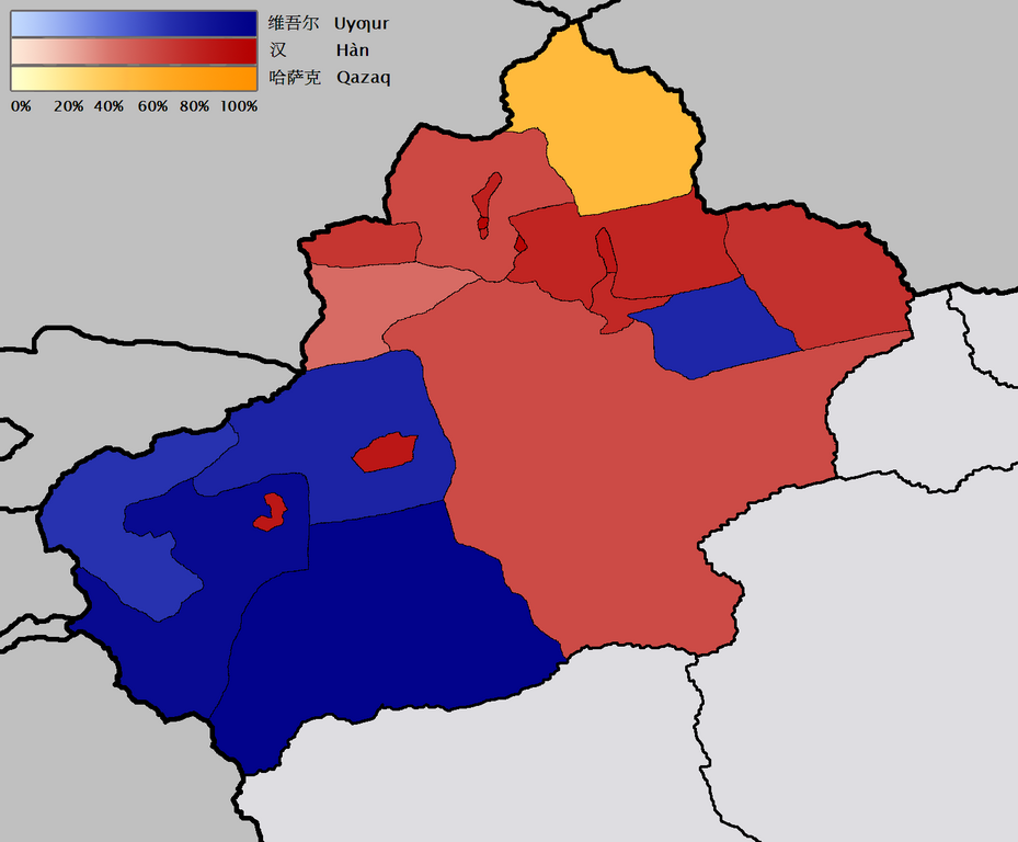
English: Map of the prefecture-level divisions of Xinjiang by ethnicity (nationality or 民族). 2000 census information is from w:en and w:de. The basis of the map is Image:Bayin Gholin.png, but I rotated the map so that the meridians are more nearly vertical, and also removed the background noise. I borrowed the colour scale from the Image:Canada election 2006 v2.png. QuartierLatin1968 21:20, 28 January 2006 (UTC)
Türkçe: Sincan'ın il düzeyi bölgelerindeki çoğunluğu oluşturan farklı etnik gruplar (minzu 民族). 2000 yılı nüfus verileri w:en ve w:de'den kaynaklanır. Haritanın temeli Image:Bayin Gholin.png'den alınmıştır, fakat meridyenleri daha dikey şekilde göstermek için harita döndürülmüştür ve gereksiz arka plan detayları çıkarılmıştır. Renk şeması Image:Canada election 2006 v2.png'den alınmıştır.
中文:新疆地域按民族(民族或民族)劃分的地圖。 2000年的人口普查信息來自w:en和w:de。 該地圖的基礎是Image:Bayin Gholin.png,但是我旋轉了地圖,使子午線更加接近垂直,並且還消除了背景噪音。 我從Image:Canada election 2006 v2.png中藉用了色階。 QuartierLatin196821:20,2006年1月28日(UTC)
Paglisensya
I, the copyright holder of this work, hereby publish it under the following licenses:

|
Tinutugutan an pagkopya, pagpanao, asin/o pagbago sa dokumentong ini sa irarom kan mga termino kan GNU Free Documentation License, Bersyon 1.2 o dawa anong mas bagong bersyon na naipublikar kan Free Software Foundation; na mayong paburubagong seksyon, mayong teksto sa front-cover, asin walang teksto sa back-cover. Igwang nakalaag na kopya kan lisensya sa seksyon na may titulong GNU Free Documentation License. |
| Nakalisensya an file na ini sa irarom kan lisensyang Creative Commons Attribution-Share Alike 3.0 Unported. | ||
| ||
| This licensing tag was added to this file as part of the GFDL licensing update. |
This file is licensed under the Creative Commons Attribution-Share Alike 2.5 Generic, 2.0 Generic and 1.0 Generic license.
- Talingkas mo ining:
- maihiras – makokopya, maipapanao, asin maipapahiling an gibo
- i-remix – ma-adapt an gibo
- Sa irarom kan mga kondisyon na ini:
- atribusyon – Dapat mong i-credit, itao an link kan lisensya, at itukdo kun may binago ini. Pwede mo ining gibuhon sa dawa anong rasonableng paagi, pero bako sa paaging ineendorso ka o an paggamit mo kan naglisensya.
- share alike – Kun ire-remix mo, babaguhon, o madagdag sa materyal, kaipuhan mong ipanao an mga ambag mo sa irarom kan parehas o katulad na lisensya.
Pwede kang makapili nin lisensya mo.
Kasaysayan kan file
Pinduton an sarong petsa/oras para mahiling ng file sa puntong idto.
| Petsa/Oras | Thumbnail | Sukol | Paragamit | Komento | |
|---|---|---|---|---|---|
| presente | 21:43, 28 Enero 2006 | | 1,474 × 1,219 (129 KB) | QuartierLatin1968 | adjusted Xizang/Qinghai boundary |
| 21:20, 28 Enero 2006 |  | 1,474 × 1,219 (129 KB) | QuartierLatin1968 | * {{en}}: Map of the prefecture-level divisions of Xinjiang by ethnicity (nationality or 民族). 2000 census information is from w:en and w:de. The basis of the map is Image:Bayin Golin.png, but I rotated the map so that the meridians |
Paggamit sa file
Ginagamit kan minasunod na pahina an file na ini:
Pankinaban na paggamit sa file
Ginagamit kan mga minasunod na wiki an file na ini:
- Paggamit sa af.wikipedia.org
- Paggamit sa ast.wikipedia.org
- Paggamit sa azb.wikipedia.org
- Paggamit sa az.wikipedia.org
- Paggamit sa ba.wikipedia.org
- Paggamit sa bg.wikipedia.org
- Paggamit sa ca.wikipedia.org
- Paggamit sa da.wikipedia.org
- Paggamit sa de.wikipedia.org
- Paggamit sa en.wikipedia.org
- Paggamit sa eo.wikipedia.org
- Paggamit sa es.wikipedia.org
- Paggamit sa fr.wikipedia.org
- Paggamit sa gl.wikipedia.org
- Paggamit sa hr.wikipedia.org
- Paggamit sa incubator.wikimedia.org
- Paggamit sa ja.wikipedia.org
- Paggamit sa kk.wikipedia.org
- Paggamit sa la.wikipedia.org
- Paggamit sa lez.wikipedia.org
- Paggamit sa lv.wikipedia.org
- Paggamit sa mn.wikipedia.org
- Paggamit sa ms.wikipedia.org
- Paggamit sa nl.wikipedia.org
- Paggamit sa nn.wikipedia.org
- Paggamit sa no.wikipedia.org
- Paggamit sa oc.wikipedia.org
- Paggamit sa pt.wikipedia.org
- Paggamit sa ru.wikipedia.org
- Paggamit sa sr.wikipedia.org
Hilingon an kadagdagan na pankinaban na paggamit sa file na ini.