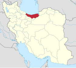
Babol County
Babol County Persiyano: شهرستان بابل | |
|---|---|
 Filband | |
 Location of Babol County in Mazandaran province (center, purple) | |
 Lokasyon kan probinsya nin Mazandaran in Iran | |
| Tagboan: 36°16′N 52°36′E / 36.267°N 52.600°ETagboan: 36°16′N 52°36′E / 36.267°N 52.600°E[1] | |
| Country | |
| Province | Mazandaran |
| Kabesera | Babol |
| Districts | Central, Babol Kenar, Bandpey-e Gharbi, Bandpey-e Sharqi, Gatab, Lalehabad |
| Hiwas | |
| • Kabuuhan | 1,578.10 km2 (609.31 sq mi) |
| Populasyon (2016)[3] | |
| • kabuuhan | 531,930 |
| • Densidad | 340/km2 (870/sq mi) |
| Sona nin oras | UTC+3:30 (IRST) |
| Babol County can be found at GEOnet Names Server, at this link, by opening the Advanced Search box, entering "-3193722" in the "Unique Feature Id" form, and clicking on "Search Database". | |
An Babol County (Persiyano: شهرستان بابل) namumugtak sa probinsya ninMazandaran, Iran. An kabisera kaini iyo an siyudad nin Babol.[4]
Historya
[baguhon | baguhon an source]An Babol county dati inaapod na Barforush kan ika-19ng siglo.[5]
Mga Dinastiya sa Babol County iyo an:
Demograpiko
[baguhon | baguhon an source]Populasyon
[baguhon | baguhon an source]Kan panahon nin 2006 sensus nasyonal, an populasyon kan county nag'abot 464,538 sa 125,187 na pagharongon.[6]an sunod na sensus kan 2011 nagtbilang nin 495,472 katawo se 149,320 na pagharongon.[7] An 2016 na sensus nagbilang an populasyon kan county nin 531,930 sa 174,351 na pagharongon.[3]
Mga Dibisyon Administratibo
[baguhon | baguhon an source]An historya nin populasyn kan Babol County asin estruktura administratibo sa laog nin tolong surunodan na sensus pinapahiling sa minassunod na table.
| Administrative Divisions | 2006[6] | 2011[7] | 2016[3] |
|---|---|---|---|
| Central District | 287,006 | 314,794 | 349,098 |
| Esbu Kola RD | 16,319 | 18,310 | 18,709 |
| Feyziyeh RD | 24,073 | 25,451 | 26,670 |
| Ganj Afruz RD | 22,792 | 23,480 | 23,024 |
| Amirkola (city) | 25,186 | 28,086 | 30,478 |
| Babol (city) | 198,636 | 219,467 | 250,217 |
| Babol Kenar District | 24,946 | 25,069 | 25,170 |
| Babol Kenar RD | 16,990 | 16,515 | 15,815 |
| Deraz Kola RD | 7,431 | 7,999 | 8,487 |
| Marzikola (city) | 525 | 555 | 868 |
| Bandpey-e Gharbi District | 25,577 | 25,876 | 26,233 |
| Khvosh Rud RD | 11,758 | 11,878 | 11,309 |
| Shahidabad RD | 10,879 | 10,681 | 9,182 |
| Khush Rudpey (city) | 2,940 | 3,317 | 5,742 |
| Bandpey-e Sharqi District | 32,522 | 33,508 | 35,232 |
| Firuzjah RD | 3,201 | 3,019 | 2,600 |
| Sajjadrud RD | 26,809 | 27,846 | 25,724 |
| Galugah (city) | 2,512 | 2,643 | 6,908 |
| Gatab District | 45,104 | 46,041 | 47,054 |
| Gatab-e Jonubi RD | 14,743 | 14,955 | 15,030 |
| Gatab-e Shomali RD | 23,405 | 23,844 | 24,650 |
| Gatab (city) | 6,956 | 7,242 | 7,374 |
| Lalehabad District | 49,383 | 50,184 | 49,142 |
| Karipey RD | 31,761 | 31,971 | 27,828 |
| Lalehabad RD | 17,197 | 17,790 | 17,323 |
| Zargar (city)[lower-alpha 1] | 425 | 423 | 3,991 |
| Total | 464,538 | 495,472 | 531,930 |
| RD = Rural District | |||
Hilnga man
[baguhon | baguhon an source]![]() Igwang relatibong medya para sa Babol County duman sa Wikimedia Commons
Igwang relatibong medya para sa Babol County duman sa Wikimedia Commons
Nota
[baguhon | baguhon an source]Toltolan
[baguhon | baguhon an source]- ↑ Plantilya:Cite map
- ↑ "Management and Planning Organization of Mazandaran, 2006" (PDF). Archived from the original (PDF) on 2013-11-16. Retrieved 2012-09-08. Unknown parameter
|url-status=ignored (help) - ↑ 3.0 3.1 3.2 "Census of the Islamic Republic of Iran, 1395 (2016)". AMAR (in Persian). The Statistical Center of Iran. p. 02. Archived from the original (Excel) on 7 October 2021. Retrieved 19 December 2022.
- ↑ Habibi, Hassan (21 June 1369). "Approval of the organization and chain of citizenship of the elements and units of the divisions of Mazandaran province, centered in Sari city". Lamtakam (in Persian). Ministry of Interior, Defense Political Commission of the Government Council. Archived from the original on 14 January 2024. Retrieved 14 January 2024.
- ↑ "Welcome to Encyclopaedia Iranica".
- ↑ 6.0 6.1 "Census of the Islamic Republic of Iran, 1385 (2006)". AMAR (in Persian). The Statistical Center of Iran. p. 02. Archived from the original (Excel) on 20 September 2011. Retrieved 25 September 2022.
- ↑ 7.0 7.1 "Census of the Islamic Republic of Iran, 1390 (2011)". Syracuse University (in Persian). The Statistical Center of Iran. p. 02. Archived from the original (Excel) on 19 January 2023. Retrieved 19 December 2022.
- ↑ "The name of the city of Zargarmahalleh in Babol County was changed to Zargar". Islamic Republic News Agency. Ministry of Interior, Cabinet of Ministers. 24 June 1400. Archived from the original on 5 August 2021. Retrieved 23 May 2023. Unknown parameter
|lang=ignored (|language=suggested) (help)
- اطلس گیتاشناسی استانهای ایران [Atlas Gitashenasi Ostanhai Iran] (Gitashenasi Province Atlas of Iran)
- Babol.tk [Babol.tk] ([1] Archived 2020-01-25 at the Wayback Machine.)
