
Ladawan:Líneas de Nazca, Nazca, Perú, 2015-07-29, DD 54.JPG

Orihinal na file (5,563 × 4,555 na pixel, pakadakula: 9.76 MB, tipo nin MIME: image/jpeg)
Sumaryo
| Pagladawan |
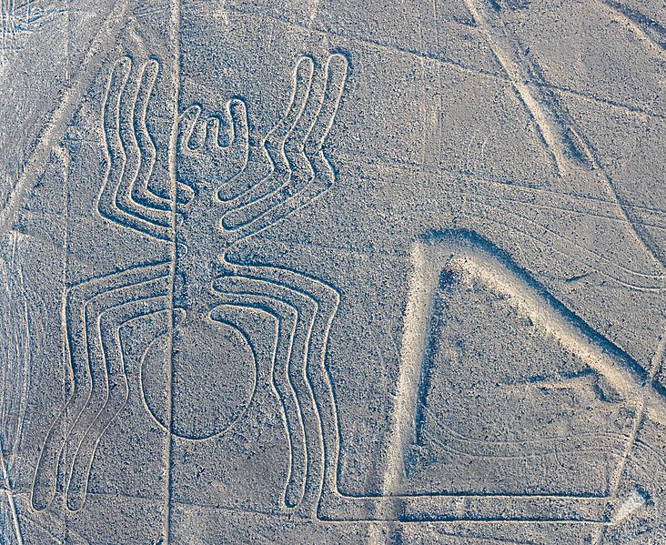
Español: Vista aérea de la "Araña", uno de los geoglifos más conocidos de las Líneas de Nazca, situadas en el Desierto de Sechura en el sur de Perú. Los geoglifos de este Patrominio de la Humanidad según la UNESCO (desde 1994) se reparten en un área de 80 km de largo entre las ciudades de Nazca y Palpa y tienen una antigüedad, según diferentes estudios, de entre 500 a.C. y 500 d.C. English: Aerial view of the "Spider", one of the most popular geoglyphs of the Nazca Lines, which are located in the Nazca Desert in southern Peru. The geoglyphs of this UNESCO World Heritage Site (since 1994) are spread over a 80 km (50 mi) plateau between the towns of Nazca and Palpa and are, according to some studies, between 500 B.C. and 500 A.D. old.
Čeština: Letecký pohled na "Pavouka", jeden z nejznámějších geoglyfů z obrazců na planině Nazca na náhorní plošině v jižním Peru.
Magyar: A „pók”, a Nazca-vonalak egyik legnépszerűbb geoglifája légi felvételen. Az 1994 óta UNESCO világörökség részét képező geoglifák egy 80 km hosszú fennsíkon találhatók Nazca és Palpa városok között, és megközelítőleg 2000 éve készültek (Nazca-sivatag, Peru)
한국어: 나스카에서 가장 유명한 지상화 중 하나인 “거미”. 페루 남부 나스카 사막에 위치한 나스카 지상화는 1994년에 유네스코 세계유산으로 지정되었는데, 나스카와 팔파 마을 사이 약 80 km에 이르는 거리에 펼쳐져 있고, 기원전 500년에서 기원후 500년 사이에 그려진 것으로 추정된다.
Македонски: Надолен поглед на геоглифот „Пајак“ — една од попознатите Наскански линии во јужно Перу.
Nederlands: De "spin", een van de tientallen geogliefen die samen bekend staan als de Nazcalijnen in Peru
Português: Vista aérea da "Aranha", um dos geoglifos mais conhecidos das Linhas de Nazca, localizados no Deserto de Sechura no sul do Peru. Os geoglifos deste Patrimônio da Humanidade segundo a UNESCO (desde 1994) estão espalhados por um platô de 80 km entre as cidades de Nazca e Palpa e têm a idade, segundo diferentes estudos, entre 500 a.C. e 500 d.C.
Français : Vue aérienne de "L'Araignée", un des géoglyphes les plus populaires de Nazca, situé dans le désert de Nazca au sud du Pérou. Les géoglyphes de ce site, classé patrimoine mondial de l'humanité par l'UNESCO depuis 1994, s'étendent sur un plateau de 80 km (50 mi) entre les villes de Nazca et de Palpa. Selon certaines études, ils auraient été tracés entre 500 av. J.C et 500 ap. J.C
Эрзянь: Аэрофотокувось "Пондомукоро" ("Spider"), те содавиксэв кевень артовкс Наски геоглифтнэде, конась ашти Сечура човарпаксясо Перунь лембеёно. Неть геоглифтнэ UNESCO-нь Весемирэнь тевкадовкс (саезь 1994-це иестэ) аштить плато лангсо 80 km (50 mi) кувалмосо Наска ды Ралпа оштнэнь ютксо, ды стявтозь-путозь ульнесть келя 500 иенть м. п. икеле ды 500 иенть юткова. |
||||||||||||||||||||
| Petsa | |||||||||||||||||||||
| Pinagkunan | Sadiring gibo | ||||||||||||||||||||
| Kagsurat |
|
||||||||||||||||||||

| Object location | | View this and other nearby images on: OpenStreetMap |
|---|
|
This image was selected as picture of the day on Wikimedia Commons for 20 August 2020. It was captioned as follows: English: Aerial view of the "Spider", one of the most popular geoglyphs of the Nazca Lines, which are located in the Nazca Desert in southern Peru. The geoglyphs of this UNESCO World Heritage Site (since 1994) are spread over a 80 km (50 mi) plateau between the towns of Nazca and Palpa and were, according to some studies, constructed between 500 B.C. and 500 A.D. Other languages:
Čeština: Letecký pohled na "Pavouka", jeden z nejznámějších geoglyfů z obrazců na planině Nazca na náhorní plošině v jižním Peru. English: Aerial view of the "Spider", one of the most popular geoglyphs of the Nazca Lines, which are located in the Nazca Desert in southern Peru. The geoglyphs of this UNESCO World Heritage Site (since 1994) are spread over a 80 km (50 mi) plateau between the towns of Nazca and Palpa and were, according to some studies, constructed between 500 B.C. and 500 A.D. Español: Vista aérea de la "Araña", uno de los geoglifos más conocidos de las Líneas de Nazca, situadas en el Desierto de Sechura en el sur de Perú. Los geoglifos de este Patrominio de la Humanidad según la UNESCO (desde 1994) se reparten en un área de 80 km de largo entre las ciudades de Nazca y Palpa y tienen una antigüedad, según diferentes estudios, de entre 500 a.C. y 500 d.C. Français : Vue aérienne de "L'Araignée", un des géoglyphes les plus populaires de Nazca, situé dans le désert de Nazca au sud du Pérou. Les géoglyphes de ce site, classé patrimoine mondial de l'humanité par l'UNESCO depuis 1994, s'étendent sur un plateau de 80 km (50 mi) entre les villes de Nazca et de Palpa. Selon certaines études, ils auraient été tracés entre 500 av. J.C et 500 ap. J.C Magyar: A „pók”, a Nazca-vonalak egyik legnépszerűbb geoglifája légi felvételen. Az 1994 óta UNESCO világörökség részét képező geoglifák egy 80 km hosszú fennsíkon találhatók Nazca és Palpa városok között, és megközelítőleg 2000 éve készültek (Nazca-sivatag, Peru) Nederlands: De "spin", een van de tientallen geogliefen die samen bekend staan als de Nazcalijnen in Peru Português: Vista aérea da "Aranha", um dos geoglifos mais conhecidos das Linhas de Nazca, localizados no Deserto de Sechura no sul do Peru. Os geoglifos deste Patrimônio da Humanidade segundo a UNESCO (desde 1994) estão espalhados por um platô de 80 km entre as cidades de Nazca e Palpa e têm a idade, segundo diferentes estudos, entre 500 a.C. e 500 d.C. Македонски: Надолен поглед на геоглифот „Пајак“ — една од попознатите Наскански линии во јужно Перу. |
Paglisensya
Another one of my pictures:,_Hartelholz,_M%C3%BAnich,_Alemania,_2020-06-27,_DD_299-308_FS.jpg) Want to see more works of mine? click here |
Under this condition:
Please, use this work legally fulfilling the terms of the license! Please, let me know if you use this work outside Wikimedia Commons sending me an email on Furthermore, if you:
please, do not hesitate to contact me. |

|
Please do not overwrite the author's version with a modified image without discussing with the author. The author would like to make corrections only from the uncompressed RAW file. This ensures that changes are preserved and are based on the best possible source to achieve a high quality. If you think that changes are required, please, get in touch with the author. Otherwise, you can upload a new image with a different name without overwriting this one. Use {{Derived from}} or {{Extracted from}} for this purpose. |
- Talingkas mo ining:
- maihiras – makokopya, maipapanao, asin maipapahiling an gibo
- i-remix – ma-adapt an gibo
- Sa irarom kan mga kondisyon na ini:
- atribusyon – Dapat mong i-credit, itao an link kan lisensya, at itukdo kun may binago ini. Pwede mo ining gibuhon sa dawa anong rasonableng paagi, pero bako sa paaging ineendorso ka o an paggamit mo kan naglisensya.
- share alike – Kun ire-remix mo, babaguhon, o madagdag sa materyal, kaipuhan mong ipanao an mga ambag mo sa irarom kan parehas o katulad na lisensya.
This image has been assessed using the Quality image guidelines and is considered a Quality image.
|
Kasaysayan kan file
Pinduton an sarong petsa/oras para mahiling ng file sa puntong idto.
| Petsa/Oras | Thumbnail | Sukol | Paragamit | Komento | |
|---|---|---|---|---|---|
| presente | 09:57, 6 Hulyo 2019 | | 5,563 × 4,555 (9.76 MB) | Poco a poco | New dev |
| 19:29, 30 Agosto 2015 |  | 6,185 × 4,745 (11.66 MB) | Poco a poco | User created page with UploadWizard |
Paggamit sa file
Ginagamit kan minasunod na pahina an file na ini:
Pankinaban na paggamit sa file
Ginagamit kan mga minasunod na wiki an file na ini:
- Paggamit sa af.wikipedia.org
- Paggamit sa ast.wikipedia.org
- Paggamit sa ca.wikipedia.org
- Paggamit sa crh.wikipedia.org
- Paggamit sa cv.wikipedia.org
- Paggamit sa el.wikipedia.org
- Paggamit sa en.wikipedia.org
- Paggamit sa en.wikivoyage.org
- Paggamit sa eo.wikipedia.org
- Paggamit sa es.wikipedia.org
- Paggamit sa et.wikipedia.org
- Paggamit sa et.wikiquote.org
- Paggamit sa fi.wikipedia.org
- Paggamit sa he.wikipedia.org
- Paggamit sa hu.wikipedia.org
- Paggamit sa hy.wikipedia.org
- Paggamit sa it.wikipedia.org
- Paggamit sa ka.wikipedia.org
- Paggamit sa kk.wikipedia.org
- Paggamit sa ko.wikipedia.org
- Paggamit sa lbe.wikipedia.org
- Paggamit sa lb.wikipedia.org
- Paggamit sa lez.wikipedia.org
- Paggamit sa lt.wikipedia.org
- Paggamit sa mk.wikipedia.org
- Paggamit sa ml.wikipedia.org
- Paggamit sa ms.wikipedia.org
- Paggamit sa mt.wikipedia.org
- Paggamit sa no.wikipedia.org
- Paggamit sa or.wikipedia.org
- Paggamit sa os.wikipedia.org
- Paggamit sa pl.wikipedia.org
- Paggamit sa pt.wikipedia.org
Hilingon an kadagdagan na pankinaban na paggamit sa file na ini.