
Ladawan:Russia-CIA WFB Map--Tunguska.png
Mayo na nin mas malinaw.
Russia-CIA_WFB_Map--Tunguska.png (631 × 321 na pixel, pakadakula: 27 KB, tipo nin MIME: image/png)

|
This map image could be re-created using vector graphics as an SVG file. This has several advantages; see Commons:Media for cleanup for more information. If an SVG form of this image is available, please upload it and afterwards replace this template with
{{vector version available|new image name}}.
It is recommended to name the SVG file “Russia-CIA WFB Map--Tunguska.svg”—then the template Vector version available (or Vva) does not need the new image name parameter. |
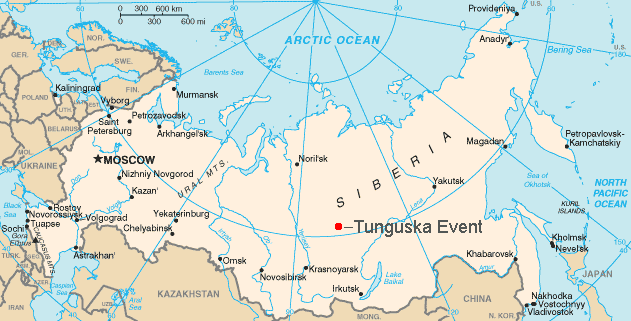
| Pagladawan |
English: Map showing the approximate location of the Tunguska event of 1908. |
||||||||
| Pinagkunan | CIA | ||||||||
| Kagsurat |
English: This is a hacked version of the public domain map Russia-CIA WFB Map.png.
User:Bobby D. Bryant made the modifications and uploaded it under the GFDL on May 21, 2005. |
||||||||
| Pagtugot (Giraray na paggamit sa file) |
|

Kasaysayan kan file
Pinduton an sarong petsa/oras para mahiling ng file sa puntong idto.
| Petsa/Oras | Thumbnail | Sukol | Paragamit | Komento | |
|---|---|---|---|---|---|
| presente | 18:41, 30 Hunyo 2012 | | 631 × 321 (27 KB) | Ras67 | cropped |
| 16:09, 11 Setyembre 2006 |  | 634 × 323 (31 KB) | Amic~commonswiki | {{Information |Description=Map showing the approximate location of the Tunguska event of 1908. |Source=This is a hacked version of the public domain map Russia-CIA WFB Map.png. [[w:User:Bobby D. Bryant|User:Bobby D. Bryan | |
| 15:35, 21 Mayo 2005 |  | 634 × 323 (29 KB) | Bobby D. Bryant~commonswiki | {{CIA-map}} |
Paggamit sa file
Ginagamit kan minasunod na pahina an file na ini:
Pankinaban na paggamit sa file
Ginagamit kan mga minasunod na wiki an file na ini:
- Paggamit sa af.wikipedia.org
- Paggamit sa ast.wikipedia.org
- Paggamit sa be.wikipedia.org
- Paggamit sa bg.wikipedia.org
- Paggamit sa bs.wikipedia.org
- Paggamit sa cs.wikipedia.org
- Paggamit sa da.wikipedia.org
- Paggamit sa el.wikipedia.org
- Paggamit sa en.wikipedia.org
- Paggamit sa eo.wikipedia.org
- Paggamit sa es.wikipedia.org
- Paggamit sa et.wikipedia.org
- Paggamit sa fa.wikipedia.org
- Paggamit sa fi.wikipedia.org
- Paggamit sa gl.wikipedia.org
- Paggamit sa hi.wikipedia.org
- Paggamit sa hu.wikipedia.org
- Paggamit sa ja.wikipedia.org
- Paggamit sa kn.wikipedia.org
- Paggamit sa li.wikipedia.org
- Paggamit sa lt.wikipedia.org
- Paggamit sa ml.wikipedia.org
- Paggamit sa ms.wikipedia.org
- Paggamit sa nn.wikipedia.org
- Paggamit sa no.wikipedia.org
- Paggamit sa pl.wikipedia.org
- Paggamit sa pt.wikipedia.org
- Paggamit sa ro.wikipedia.org
- Paggamit sa sco.wikipedia.org
- Paggamit sa sh.wikipedia.org
- Paggamit sa simple.wikipedia.org
- Paggamit sa si.wikipedia.org
- Paggamit sa sk.wikipedia.org
- Paggamit sa sv.wikipedia.org
- Paggamit sa ta.wikipedia.org
- Paggamit sa uk.wikipedia.org
- Paggamit sa uz.wikipedia.org
- Paggamit sa vi.wikipedia.org
- Paggamit sa war.wikipedia.org
- Paggamit sa zh-yue.wikipedia.org