Salog Indus
Appearance
| Indus | |
|---|---|
Sindhu, Mehran[1] | |
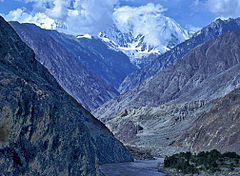
 The Indus Gorge is formed as the Indus River bends around the Nanga Parbat massif, shown towering behind, defining the western anchor of the Himalayan mountain range. | |
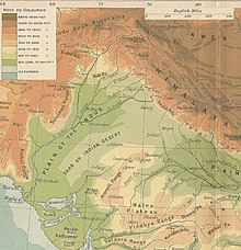
 The course and major tributaries of the Indus river | |
| China, India, Pakistan Sovereignty in the Kashmir region is disputed.[2] | |
| Tibet Autonomous Region, Ladakh, Gilgit-Baltistan, Khyber Pakhtunkhwa, Punjab, and Sindh | |
| Leh, Skardu, Dasu, Besham, Thakot, Swabi, Dera Ismail Khan, Mianwali, Bhakkar, Sukkur, Hyderabad, Karachi | |
| Pinagkukuanan | Lake Manasarovar[3] |
| - kinamumugtakan | Tibetan Plateau |
| Sarong pinagkukuanang agos | |
| - kinamumugtakan | Shiquanhe, Ngari Prefecture, Tibet Autonomous Region, People's Republic of China |
| - tagboan | 32°29′54″N 79°41′28″E / 32.49833°N 79.69111°E |
| - kalangkawan | 4,255 m (13,960 ft) |
| Bunganga | Arabian Sea (primary), Rann of Kutch (secondary) |
- kinamumugtakan | Indus River Delta (primary), Pakistan
Kori Creek (secondary), India |
- tagboan | 23°59′40″N 67°25′51″E / 23.99444°N 67.43083°E |
- Kalangkawan | 0 m (0 ft) |
| Laba | 3,180 km (1,980 mi)[4] |
| Sukol kan basin | 1,120,000 km2 (430,000 sq mi)[4] |
| Diskarga | |
| - kinamumugtakan | Indus Delta, Arabian Sea, Pakistan |
| - katampatan | 5,533 m3/s (195,400 cu ft/s)[5] |
| - pinakasagad-baba | 1,200 m3/s (42,000 cu ft/s) |
| - pinakasagad-taas | 58,000 m3/s (2,000,000 cu ft/s) |
| Diskarga | |
| - kinamumugtakan | Sukkur |
| - katampatan | 5,673.486 m3/s (200,357.3 cu ft/s)[6] |
| Diskarga | |
| - kinamumugtakan | Mithankot |
| - katampatan | 5,812.326 m3/s (205,260.4 cu ft/s)[6] |
| Diskarga | |
| - kinamumugtakan | Tarbela Dam |
| - katampatan | 2,469 m3/s (87,200 cu ft/s) |
| Mga pigpapahiling kan basin | |
| Mga sanga nin salog | |
| - wala | Zanskar River, Suru River, Soan River, Panjnad River, Ghaggar-Hakra River, |
| - tuo | Shyok River, Hunza River, Gilgit River, Swat River, Kunar River, Kabul River, Kurram River, Gomal River, Zhob River |
An Indus (/ˈɪndəs/ IN-dəs) iyo an sarong transboundary river kan Asya asin sarong trans-Himalayan na salog kan South asin Central Asia.[7] An 3,120 km (1,940 mi)[4] salog Nagsasakat sa burabod kan bukid sa amihanan-subangan kan Bukid Kailash sa Solnopan na Tibet, nagbubulos pasiring sa amihanan-solnopan sa paagi kan pig-iiriwalan na rehiyon kan Kashmir,[2] nagtitiko pasiring sa wala pagkatapos kan Nanga Parbat massif, asin nagbubulos pasiring sa south-by-southwest sa paagi kan Pakistan, bago magluwas pasiring sa Dagat Arabo harani sa port city kan Karachi.[1][8]
Toltolan
[baguhon | baguhon an source]- ↑ 1.0 1.1 Ahmad, Nafis; Lodrick, Deryck (6 February 2019). "Indus River". Encyclopedia Britannica. Retrieved 5 February 2021.
- ↑ 2.0 2.1 "Kashmir: region, Indian subcontinent". Encyclopædia Britannica. Retrieved 16 July 2016. Quote: "Kashmir, region of the northwestern Indian subcontinent. It is bounded by the Uygur Autonomous Region of Xinjiang to the northeast and the Tibet Autonomous Region to the east (both parts of China), by the Indian states of Himachal Pradesh and Punjab to the south, by Pakistan to the west, and by Afghanistan to the northwest. The northern and western portions are administered by Pakistan and comprise three areas: Azad Kashmir, Gilgit, and Baltistan, ... The southern and southeastern portions constitute the Indian state of Jammu and Kashmir. The Indian- and Pakistani-administered portions are divided by a "line of control" agreed to in 1972, although neither country recognizes it as an international boundary. In addition, China became active in the eastern area of Kashmir in the 1950s and since 1962 has controlled the northeastern part of Ladakh (the easternmost portion of the region)."
- ↑ Ahmad, Ijaz; Zhang, Fan; Tayyab, Muhammad; Anjum, Muhammad Naveed; Zaman, Muhammad; Liu, Junguo; Farid, Hafiz Umar; Saddique, Qaisar (15 November 2018). "Spatiotemporal analysis of precipitation variability in annual, seasonal and extreme values over upper Indus River basin" (in en). Atmospheric Research 213: 346–60. doi:. ISSN 0169-8095. Bibcode: 2018AtmRe.213..346A. https://www.sciencedirect.com/science/article/pii/S0169809517312796.
- ↑ 4.0 4.1 4.2 Shrestha AB, Agrawal NK, Alfthan B, Bajracharya SR, Maréchal J, van Oort B (eds.). The Himalayan Climate and Water Atlas: Impact of Climate Change on Water Resources in Five of Asia's Major River Basins (in English). International Centre for Integrated Mountain Development. p. 58. ISBN 978-92-9115-357-2.
- ↑ Amir, Khan; Naresh, Pant; Anuj, Goswami; Ravish, Lal; Rajesh, Joshi (Dec 2015). "Critical Evaluation and Assessment of Average Annual Precipitation in The Indus, The Ganges and The Brahmaputra Basins, Northern India – Himalayan Cryospheric Observations and Modelling (HiCOM)".
- ↑ 6.0 6.1 "Rivers Network". 2020. Archived from the original on 2022-06-29. Retrieved 2023-11-12.
- ↑ Richardson, Hugh E.; Wylie, Turrell V.; Falkenheim, Victor C.; Shakabpa, Tsepon W. D. (3 March 2020). "Tibet". Encyclopedia Britannica. Retrieved 9 August 2021.
historic region and autonomous region of China that is often called "the roof of the world." It occupies a vast area of plateaus and mountains in Central Asia
- ↑ Natural Wonders of the World. Penguin Random House/DK & Smithsonian. 2017. p. 240. ISBN 978-1-4654-9492-4.
