
San Miguel, Bulacan
San Miguel | ||
|---|---|---|
 | ||
| ||
 Kinamumugtakan kan San Miguel | ||
 | ||
| Tagboan: 15°8′45″N 120°58′42″E Tagboan: 15°8′45″N 120°58′42″E | ||
| Nasyon | Filipinas | |
| Pigtugdas | Setyembre 29, 1725 | |
| Barangay | 49 | |
| Pamamahala | ||
| • Electorado | 100,163 votantes (9 Mayo 2022) | |
| Hiwas | ||
| • Kabuuhan | 231.40 km2 (89.34 sq mi) | |
| Elebasyon | 20 m (70 ft) | |
| Populasyon (Mayo 1, 2020)[2] | ||
| • kabuuhan | 172,073 | |
| • Densidad | 740/km2 (1,900/sq mi) | |
| • Saro | 40,269 | |
| Economia | ||
| • Klase | primero klaseng banwaan | |
| • Ingresos | ₱434,145,715.38 (2020) | |
| • Activos | ₱892,157,509.50 (2020) | |
| • Pasivos | ₱485,827,738.03 (2020) | |
| • Gastos | ₱382,861,190.90 (2020) | |
| Kodigo nin postal | 3011 | |
| PSGC | 031421000 | |
| Kodigo telefonico | 44 | |
| Tataramon | tataramon na Tagalog Tataramon na Pampango | |

An San Miguel sarong primera klaseng banwaan kan provincia nin Bulacan, Filipinas. An designadong zip code kaini iyo 3011. Susog sa sensus kan 1 Mayo 2020, igwa ining 172,073 katawong nag-eerok digdi sa 40,269 kaharongan. Igwa ining sukol na 231.40 kilometro kwadrado.
Mga barangay
[baguhon | baguhon an source]An San Miguel nababanga sa 49 barangay.
|
|
|
Demograpiko
[baguhon | baguhon an source]| Taon | Tawo | ±% p.a. |
|---|---|---|
| 1903 | 14,919 | — |
| 1918 | 17,988 | +1.25% |
| 1939 | 26,759 | +1.91% |
| 1948 | 38,093 | +4.00% |
| 1960 | 43,195 | +1.05% |
| 1970 | 58,712 | +3.11% |
| 1975 | 66,870 | +2.64% |
| 1980 | 73,113 | +1.80% |
| 1990 | 91,124 | +2.23% |
| 1995 | 108,147 | +3.26% |
| 2000 | 123,824 | +2.94% |
| 2007 | 138,839 | +1.59% |
| 2010 | 142,854 | +1.04% |
| 2015 | 153,882 | +1.43% |
| 2020 | 172,073 | +2.22% |
| Toltolan: Philippine Statistics Authority[3][4][5][6] | ||
Galeri
[baguhon | baguhon an source]-
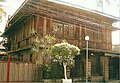 Residencia Villacorte
 -
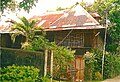 Residencia Veneracion
 -
 Nasyunal na Parke nin Biak-na-Bato


Toltolan
[baguhon | baguhon an source]- ↑ Error: Unable to display the reference properly. See the documentation for details.
- ↑ "2020 Census of Population and Housing (2020 CPH) Population Counts Declared Official by the President". Hulyo 7, 2021. Check date values in:
|date=(help) - ↑ Sensus kan Populasyon (2015). "Region III (Sentral Luzon)". Kabuuhang Populasyon kan lambang Provincia, Syudad, Banwaan asin Barangay. PSA. Retrieved 20 Jun 2016.
- ↑ Census of Population and Housing (2010). "Rehiyon III (Sentral Luzon)". Kabuuhan populasyon sa lambang Provincia, Syudad, Banwaan asin Barangay. NSO. Retrieved 29 Jun 2016.
- ↑ Mga Sensus kan Populasyon (1903–2007). "Rehiyon III (Sentral Luzon)". Table 1. Population Enumerated in Various Censuses by Province/Highly Urbanized City: 1903 to 2007. NSO.
- ↑ "Province of Bulacan". Municipality Population Data. LWUA Research Division. Retrieved 17 December 2016.