
Panglao
Panglao | |
|---|---|
 | |
 Kinamumugtakan kan Panglao | |
 | |
| Tagboan: 9°34′44″N 123°44′42″E Tagboan: 9°34′44″N 123°44′42″E | |
| Nasyon | Filipinas |
| Pigtugdas | 1803 |
| Barangay | 10 |
| Pamamahala | |
| • Electorado | 28,052 votantes (9 Mayo 2022) |
| Hiwas | |
| • Kabuuhan | 47.79 km2 (18.45 sq mi) |
| Elebasyon | 10 m (30 ft) |
| Populasyon (Mayo 1, 2020)[2] | |
| • kabuuhan | 39,839 |
| • Densidad | 830/km2 (2,200/sq mi) |
| • Saro | 8,694 |
| Economia | |
| • Klase | ikaapat na klaseng banwaan |
| • Ingresos | ₱225,020,696.32 (2020) |
| • Activos | ₱798,370,717.86 (2020) |
| • Pasivos | ₱177,706,704.96 (2020) |
| • Gastos | ₱201,198,222.10 (2020) |
| Kodigo nin postal | 6340 |
| PSGC | 0701233000 |
| Kodigo telefonico | 38 |
| Tataramon | Diyalektong Boholano Tataramon na Cebuano tataramon na Tagalog |
| Websityo | panglaolgu |
An Panglao sarong ikaapat na klaseng Filipinas kan Bohol, Filipinas. An designadong zip code kaini iyo 6340.
Sosog sa sensus kan 1 Mayo 2020, igwa ining 39,839 katawong nag-eerok digdi sa 8,694 kaharongan.
Igwa ining sukol na 47.79 kilometro kwadrado.
Mga barangay
[baguhon | baguhon an source]An Panglao nababanga sa 10 barangay.
- Bil-isan
- Bolod
- Danao
- Doljo
- Libaong
- Looc
- Lourdes
- Poblacion
- Tangnan
- Tawala
Demograpiko
[baguhon | baguhon an source]| Taon | Tawo | ±% p.a. |
|---|---|---|
| 1903 | 7,050 | — |
| 1918 | 9,065 | +1.69% |
| 1939 | 9,411 | +0.18% |
| 1948 | 11,274 | +2.03% |
| 1960 | 11,836 | +0.41% |
| 1970 | 13,309 | +1.18% |
| 1975 | 13,624 | +0.47% |
| 1980 | 14,547 | +1.32% |
| 1990 | 17,004 | +1.57% |
| 1995 | 18,095 | +1.17% |
| 2000 | 21,337 | +3.60% |
| 2007 | 25,558 | +2.52% |
| 2010 | 28,603 | +4.18% |
| 2015 | 33,553 | +3.09% |
| 2020 | 39,839 | +3.43% |
| Toltolan: Philippine Statistics Authority[3][4][5][6] | ||
Mga ladawan
[baguhon | baguhon an source]-
 Nagbabasketbol sa Panglao, Bohol
 -
 Panglao Island Nature Resort
 -
 Alona Beach, Panglao, Bohol
 -
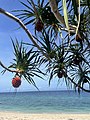 Pandan sa isla nin Balicasag

.jpg)


Toltolan
[baguhon | baguhon an source]- ↑ Error: Unable to display the reference properly. See the documentation for details.
- ↑ "2020 Census of Population and Housing (2020 CPH) Population Counts Declared Official by the President". Hulyo 7, 2021. Check date values in:
|date=(help) - ↑ Sensus kan Populasyon (2015). "Rehiyon VII (Sentral Bisaya)". Kabuuhang Populasyon kan lambang Provincia, Syudad, Banwaan asin Barangay. PSA. Retrieved 20 Jun 2016.
- ↑ Census of Population and Housing (2010). "Rehiyon VII (Sentral Bisaya)". Kabuuhan populasyon sa lambang Provincia, Syudad, Banwaan asin Barangay. NSO. Retrieved 29 Jun 2016.
- ↑ Mga Sensus kan Populasyon (1903–2007). "Rehiyon VII (Sentral Bisaya)". Table 1. Population Enumerated in Various Censuses by Province/Highly Urbanized City: 1903 to 2007. NSO.
- ↑ "Province of". Municipality Population Data. LWUA Research Division. Retrieved 17 December 2016.
Mga panluwas na takod
[baguhon | baguhon an source]- PhilAtlas.com
- Philippine Standard Geographic Code
- Local Governance Performance Management System
- Municipality of Panglao Archived 2009-01-24 at the Wayback Machine.